Kentucky Route 149
Kentucky Route 149 (KY 149) is a 10.640-mile-long (17.123 km) state highway in Clay County, Kentucky. It runs from U.S. Route 421 (US 421) and KY 80 southeast of Manchester to KY 66 in rural Clay County south of Oneida.
| ||||
|---|---|---|---|---|
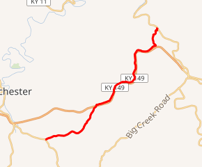
KY 149 highlighted in red | ||||
| Route information | ||||
| Maintained by KYTC | ||||
| Length | 10.640 mi[1] (17.123 km) | |||
| Major junctions | ||||
| West end | ||||
| East end | ||||
| Location | ||||
| Counties | Clay | |||
| Highway system | ||||
| ||||

Major intersections
The entire route is in Clay County.
| Location | mi[1] | km | Destinations | Notes | |
|---|---|---|---|---|---|
| | 0.000 | 0.000 | Southern terminus | ||
| | 4.885 | 7.862 | Northern terminus of KY 873 | ||
| | 10.640 | 17.123 | Eastern terminus | ||
| 1.000 mi = 1.609 km; 1.000 km = 0.621 mi | |||||
gollark: This is widely considered unethical.
gollark: You are increasing suffering for no particularly good reason.
gollark: Yes, which is actually bad.
gollark: It's just the same thing plus torture. Which is probably worse.
gollark: This is... not better?
References
- "Official DMI Route Log". Kentucky Transportation Cabinet. Retrieved July 2, 2015.
This article is issued from Wikipedia. The text is licensed under Creative Commons - Attribution - Sharealike. Additional terms may apply for the media files.