Kentucky Route 13
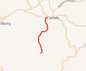
Kentucky Route 13 (KY 13) is a 5.5-mile-long (8.9 km) state highway located within Nicholas County in the U.S. state of Kentucky. The southern terminus of the route is at the Bourbon-Nicholas county line south of Carlisle. The northern terminus is at KY 36 in Carlisle.
| ||||
|---|---|---|---|---|

KY 13 highlighted in red | ||||
| Route information | ||||
| Maintained by KYTC | ||||
| Length | 5.516 mi[1] (8.877 km) | |||
| Major junctions | ||||
| South end | Bourbon–Nicholas county line south of Carlisle | |||
| North end | ||||
| Location | ||||
| Counties | Nicholas | |||
| Highway system | ||||
| ||||
Route description
Kentucky Route 13 originates at the Bourbon/Nicholas County line and travels north, forming an intersection with KY 3316. It then curves slightly northwest and forms a junction with KY 386 (Carpenter Road) before curving back toward the northeast. KY 13 ends at an intersection with KY 36 in Carlisle. It is known as Lower Jackstown Road for its entirety.
Major intersections
The entire route is in Nicholas County.
| Location | mi[1] | km | Destinations | Notes | |
|---|---|---|---|---|---|
| | 0.000 | 0.000 | Bourbon–Nicholas county line | Southern terminus | |
| | 0.558 | 0.898 | Southern terminus of KY 3316 | ||
| | 1.767 | 2.844 | Southern terminus of KY 386 | ||
| Carlisle | 5.516 | 8.877 | Northern terminus | ||
| 1.000 mi = 1.609 km; 1.000 km = 0.621 mi | |||||
gollark: Also energetic infusers.
gollark: You *can* actually just mine certus quartz.
gollark: Some lizards and stuff lay eggs. Chickens are comparatively recent.
gollark: Eggs came first. Eggs definitely came first.
gollark: GTech uses a new "extreme management" concept where divisions are created on-demand and at random, and people are assigned to multiple divisions, with managers assigned depending on who is least suitable for the position.
References
- "Kentucky Transportation Cabinet - Division of Planning - Highway Information System Official Milepoint Route Log Extract". Archived from the original on April 30, 2007. Retrieved 2007-04-13.
This article is issued from Wikipedia. The text is licensed under Creative Commons - Attribution - Sharealike. Additional terms may apply for the media files.
