Kent Township, Warren County, Indiana
Kent Township is one of twelve townships in Warren County, Indiana, United States. According to the 2010 census, its population was 428 and it contained 196 housing units.[2]
Kent Township | |
|---|---|
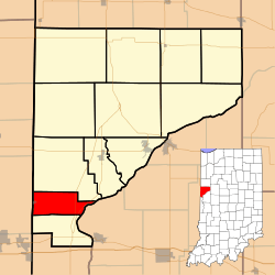 Location of Kent Township in Warren County | |
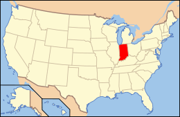 Location of Indiana in the United States | |
| Coordinates: 40°11′44″N 87°28′32″W | |
| Country | United States |
| State | Indiana |
| County | Warren |
| Government | |
| • Type | Indiana township |
| Area | |
| • Total | 14.11 sq mi (36.5 km2) |
| • Land | 14 sq mi (40 km2) |
| • Water | 0.11 sq mi (0.3 km2) 0.78% |
| Elevation | 692 ft (211 m) |
| Population (2010) | |
| • Total | 428 |
| • Density | 30.6/sq mi (11.8/km2) |
| Time zone | UTC-5 (Eastern (EST)) |
| • Summer (DST) | UTC-4 (EDT) |
| ZIP Code | 47993 |
| Area code(s) | 765 |
| GNIS feature ID | 453524 |
History
Kent Township was created in September 1864 from a section of Mound Township.[3]
Geography
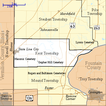
According to the 2010 census, the township has a total area of 14.11 square miles (36.5 km2), of which 14 square miles (36 km2) (or 99.22%) is land and 0.11 square miles (0.28 km2) (or 0.78%) is water.[2] It contains one town, State Line City, which is in the far western part of the township next to the Indiana / Illinois border.
Transportation
Both Indiana State Road 63 and Indiana State Road 263 pass through the eastern part of the township from north to south.[6][7]
A Norfolk Southern Railway line enters the township from Danville, Illinois and passes through State Line City, continuing northeast toward the county seat of Williamsport.[8]
Education
Kent Township is part of the Metropolitan School District of Warren County.[9]
Government
Kent Township has a trustee who administers rural fire protection and ambulance service, provides poor relief, manages cemetery care, and performs farm assessment, among other duties. The trustee is assisted in these duties by a three-member township board. The trustees and board members are elected to four-year terms.[10]
Kent Township is part of Indiana's 8th congressional district, Indiana House of Representatives District 42,[11] and Indiana State Senate District 38.[12]
References
- "US Board on Geographic Names". United States Geological Survey. October 25, 2007. Retrieved 2017-05-09.
- "Population, Housing Units, Area, and Density: 2010 - County -- County Subdivision and Place -- 2010 Census Summary File 1". United States Census. Archived from the original on 2020-02-12. Retrieved 2013-05-10.
- Warren County Historical Society 1966, p. 28.
- "Gopher Hill Cemetery". Geographic Names Information System. United States Geological Survey. Retrieved 2011-01-27.
- "Masonic Cemetery". Geographic Names Information System. United States Geological Survey. Retrieved 2011-01-27.
- "State Road 63". Highway Explorer. Archived from the original on 2012-03-09. Retrieved 2010-09-21.
- "State Road 263". Highway Explorer. Archived from the original on 2012-04-06. Retrieved 2010-09-21.
- "State of Indiana 2012 Rail System Map" (PDF). Indiana Department of Transportation. 2012. Retrieved 2013-12-02.
- "Corporation Snapshot, M S D Warren County #8115". Indiana Department of Education. Archived from the original on 2002-07-06. Retrieved 2011-01-27.
- "Government". United Township Association of Indiana. Retrieved 2011-01-06.
- "Indiana Senate" (PDF). State of Indiana. Retrieved 2013-12-02.
- "Indiana House Districts" (PDF). State of Indiana. Retrieved 2013-12-02.
- "Kent Township, Warren County, Indiana". Geographic Names Information System. United States Geological Survey. Retrieved 2009-09-24.
- United States Census Bureau TIGER/Line Shapefiles
Bibliography
- Goodspeed, Weston A. (1883). "Part II. History of Warren County". Counties of Warren, Benton, Jasper and Newton, Indiana. Chicago: F. A. Battey and Company. pp. 31–156. Retrieved 2010-09-19.
- Clifton, Thomas, ed. (1913). Past and Present of Fountain and Warren Counties Indiana. Indianapolis: B. F. Bowen and Company. pp. 201–335. Retrieved 2010-09-19.
- Warren County Historical Society (1966). A History of Warren County, Indiana. Williamsport, Indiana.
- Warren County Historical Society (2002). A History of Warren County, Indiana (175th Anniversary Edition). Williamsport, Indiana.
External links
Places adjacent to Kent Township, Warren County, Indiana | |
|---|---|
Municipalities and communities of Warren County, Indiana, United States | ||
|---|---|---|
| Towns | Map of Indiana highlighting Warren County | |
| Townships | ||
| Unincorporated communities | ||
| Ghost towns | ||
| Footnotes | ‡This populated place also has portions in an adjacent county or counties | |