Kengtung Airport
Kengtung Airport is an airport in Kengtung, Myanmar (IATA: KET, ICAO: VYKG).
Kengtung Airport | |||||||||||
|---|---|---|---|---|---|---|---|---|---|---|---|
| Summary | |||||||||||
| Location | Kengtung, Myanmar | ||||||||||
| Elevation AMSL | 2,705 ft / 824 m | ||||||||||
| Coordinates | 21°18′06″N 099°38′10″E | ||||||||||
| Map | |||||||||||
 KET Location of airport in Myanmar | |||||||||||
| Runways | |||||||||||
| |||||||||||
Airlines and destinations
| Airlines | Destinations |
|---|---|
| Golden Myanmar Airlines | Mandalay |
| Myanmar National Airlines | Heho, Mandalay |
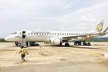
An Embraer 190 of Myanmar National Airline at Kyaing Tong Airport
gollark: According to `units`, the amount of energy needed to list a 100kg thing two metres is 0.4 dietary calories. That's totally manageable.
gollark: The Consortium.
gollark: Or with some I/O bits, if you really wanted to... search... real-life sorted lists?
gollark: Why would that be an entire spell? It would only be used as part of other things, presumably.
gollark: How inefficient and beelike of them!
This article is issued from Wikipedia. The text is licensed under Creative Commons - Attribution - Sharealike. Additional terms may apply for the media files.