Kel, Azad Kashmir
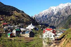
Kel (Urdu: کیل ) is a village in Neelum Valley, Azad Kashmir, Pakistan.
Kel کیل | |
|---|---|
 A view of the village | |
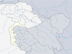
 Kel | |
| Coordinates: 34.826914°N 74.3466764°E | |
| Administering Country | |
| Self-governing jurisdiction | Azad Kashmir |
| District | Neelum |
| Government | |
| • Body | Azad Kashmir |
| Elevation | 2,097 m (6,879 ft) |
| Languages | |
| • Official | Kashmiri, Hindko, Urdu |
| Time zone | PST |
Geography
Kel is about 19 kms from Sharda. Kel is the land of Highest Mountain, 20000 feet high Sar Wali peak and Dozen others, i.e Naril Chita Par, Hariparbat, Shounter Pass, Lal Buti etc. In Kel there are about 200 Lakes including large and small. Mostly Forest Covered area.
Wildlife includes brown bears and other wild animals. Tigers and a Snow leopard have been seen there.
Main Tribes are: Mughal Mir But Awan Gujar
Spoken Languages are:
Hindko
Kashmiri
Pashto
Urdu
Geological Features:
Highest Mountains Precambrian to recent age Rocks Large of Gemstone, Kashmir Ruby is found in Kel at Nangi Mali Mine and surroundings. Many others Gemstones i.e Garnet, Neelum, Mica, Tourmaline, Aqua Marine, Chalkopyrite, Also Industrial Minerals.
Transport
Buses run daily between Muzaffarabad and Kel.
Facilities
Private hotels and a rest house, run by AJK Tourism and Archaeology Department, are available for tourists. It has a bank, college, hospital and a bazaar.[1]
References
- "Neelum Valley". Azad Jammu & Kashmir Council. Archived from the original on 27 August 2013. Retrieved 7 October 2012.