Kayser Mountain
Kayser Mountain (Danish: Kayser Bjerg) is a mountain in Hall Land, NW Greenland. Administratively it is part of the Northeast Greenland National Park. This peak was named after German geologist and paleontologist Emanuel Kayser.
| Kayser Mountain | |
|---|---|
| Kayser Bjerg | |
| Highest point | |
| Elevation | 1,094 m (3,589 ft) [1] |
| Coordinates | 81°33′15″N 58°58′28″W [1] |
| Geography | |
| Location | Hall Land, Greenland |
| Parent range | Haug Range |
| Climbing | |
| First ascent | Unknown |
Geography
Kayser Mountain is located at the eastern end of the Haug Range in northern Hall Land, at the southern limit of the Polaris Foreland. It rises 6 km to the southwest of the shore of the Newman Bay fjord.[2] With a height of 1,094 metres (3,589 ft), Kayser Mountain is the highest elevation of Hall Land and of the Haug Range.[1]
Brachiopod fossils of genus Pentamerus dating back to the Lower Silurian have been found in this mountain.[3]
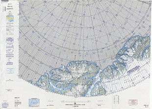 Map of the Nares Strait area. |
gollark: You're wrong then.
gollark: You're wrong, actually.
gollark: I have ALSO never broken bones.
gollark: Consume an apionic hexahedron, lyricł.y
gollark: https://skynet3.osmarks.net/ ← "chat client"
References
- GoogleEarth
- "Kayser Bjerg". Mapcarta. Retrieved 8 July 2016.
- Jin, Jisuo (2009). "SULCIPENTAMERUS(PENTAMERIDA, BRACHIOPODA) FROM THE LOWER SILURIAN WASHINGTON LAND GROUP, NORTH GREENLAND". Palaeontology. 52: 385–399. doi:10.1111/j.1475-4983.2009.00849.x.
This article is issued from Wikipedia. The text is licensed under Creative Commons - Attribution - Sharealike. Additional terms may apply for the media files.