Katsuren Peninsula
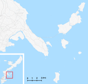
The Katsuren Peninsula (勝連半島, Katsuren hantō, Okinawan: Kacchin) is a peninsula on Okinawa Island.[1] It is bordered by Nakagusuku Bay to the south, Kin Bay to the north, and the Pacific Ocean to the east.[2] The entire peninsula is part of Uruma City.[3] Katsuren Castle is on the south-central part of the peninsula.[4] The Kaichū Dōro is a road connecting the Katsuren Peninsula to Henza Island. Offshore, coral reefs are found.[5]
Katsuren Peninsula and the Yokatsu Islands
United States military relating to the Katsuren Peninsula
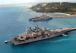
White Beach Naval Port
Buckner Bay - White Beach Naval Port Facility is located on the Katsuren Peninsula.[6][7] There once was a plan, the "White Beach Plan," to relocate United States Marine Corps Air Station Futenma to the White Beach Training Area. However, it was not effected.[8]
Nearby islands
- The eight Yokatsu Islands, which include:
- Ikei Island
- Hamahiga Island
- Henza Island
- Minamiukibara Island
- Miyagi Island
- Tsuken Island
- Ukibara Island
- Yabuchi Island
Other peninsulas on Okinawa
- Chinen Peninsula
- Henoko Peninsula
- Motobu Peninsula
- Yomitan peninsula
gollark: Also against.
gollark: i̶ ͠w̍ảt̓c̆h̨ȅd̎ ͪt͋h҉eͤ ̫a̔c̸t̥u̼àl̰ ̕r̩e̯w̠ịnͬd̵ ̒a̲n͡d̠ ͮḓi̋d̕ ̇n͗òtͧ ͣg̕ḛt͢ ͠h̰ów̓ ̂i̒t̮ ̄m͠a̤n̡åg̨e͌d̀ ̥tͩo̘ ͗g̎e̠t̑ ͠t̲h̨ät͕ ̳m̟uͧc͢h̍ ̉d͋iͩsͯl̝i̔k̤e̺s̀.̔ ̳i͐ ̷dͫǐs͕l͒ḯk͙e̊d̀ ͦi͜tͪ ͙b̒e̽c͒ḁuͪs̸e̽ ̇i̍t̞ ̸w͆aͧš ̔c̄r̴ȉn̿g͉eͮy͠ ̻a̒n͜dͦ ̽o̫b̪nͨo͑x̀ỉōǘs͕ ͥb̨u̖t̳ ͊p̒e̍o̧p̆ĺe͜ ͦṃuͫst have liked it because mainstream people like fortnite and other cringey stuff in this video.many comm҉ents say "i do not kn҉ow any of these gu҉ys" but i think featuring creators from all over the world is quite a good idea (executed awfully). if all rewinds had always the same people it would not be interesting at all.and guess what҉ is worse and more cringey than the actual rewind? the ҉pewdiepie one!
gollark: Because you're STOOPID.
gollark: WHY would you do that?
gollark: <@341618941317349376> `[],0,"0"`, what's your solution?
See also
- Chinen Cape
- Yakena Straits Observatory
References
- Jessica Elzea Kogel (2006). Industrial Minerals & Rocks: Commodities, Markets, and Uses. SME. pp. 1109–. ISBN 978-0-87335-233-8.
- South China Morning Post: The stunning fortresses of Okinawa have endured centuries of conflict | Post Magazine | South China Morning Post, accessdate: March 31, 2017
- Google Maps one: 26°22'45.0"N 127°51'27.0"E - Google Maps, accessdate: March 31, 2017
- Google Maps: https://www.google.com/maps/place/26°19'48.0"N+127°52'43.0"E/@26.33,127.8523468,13z/data=!4m5!3m4!1s0x0:0x0!8m2!3d26.33!4d127.878611?hl=en, accessdate: March 31, 2017
- Ryukyu Shimpo – Okinawa, Japanese newspaper, local news » Katsuren Peninsula: rich sea where coral reefs live: Ryukyu Shimpo – Okinawa, Japanese newspaper, local news » Katsuren Peninsula: rich sea where coral reefs live, accessdate: March 31, 2017
- The Japan Times: White Beach base site said credible | The Japan Times, accessdate: March 31, 2017
- Okinawa Hai » White Beach – Okinawa Installation Overview: White Beach, accessdate: March 31, 2017
- Jessica Elzea Kogel (2006). Industrial Minerals & Rocks: Commodities, Markets, and Uses. SME. pp. 1109–. ISBN 978-0-87335-233-8.
External links and references
- A google map
- One link
- A second link
- On the Yakena Straits Observatory
- A shot of the Waitui Cut
- Noroga and Remnants of an Old Sugar Factory, on Katsuren Peninsula
- One Youtube, exploring the Katsuren Peninsula
- Island-hopping in the Katsuren Peninsula
- Searching for Waitui on the Katsuren Peninsula
- An article on the geology of Kasturen Peninsula
- More geology
Naha (capital) | ||
| Core city | ||
| Cities |
| |
| Districts | ||
List of mergers in Okinawa Prefecture
| ||
This article is issued from Wikipedia. The text is licensed under Creative Commons - Attribution - Sharealike. Additional terms may apply for the media files.