Kasanje, Uganda
Kasanje | |
|---|---|
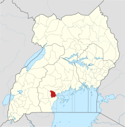
 Kasanje Map of Uganda showing the location of Kasanje | |
| Coordinates: 00°15′54″S 31°45′54″E | |
| Country | |
| Region | Central Uganda |
| District | Kalungu District |
| Elevation | 1,280 m (4,200 ft) |
| Time zone | UTC+3 (EAT) |
Kasanje is a location in Central Uganda.
Location
Kasanje is located in Kalungu District, Central Uganda. It lies approximately 10 kilometres (6.2 mi), by road, northeast of Masaka, the nearest large city.[1] This location lies approximately 14 kilometres (8.7 mi), by road, south of Kalungu, where the district headquarters are located.[2] The coordinates of Kasanje are:00 15 54S, 31 45 54E (Latitude:-0.2650; Longitude:31.7650).
Landmarks
Some of the landmarks near Kasanje include the following:
- Kalungu Health Center III - A public health center, administered by Kalungu District Administration, lies approximately 2 kilometres (1.2 mi), by road, west of Kasanje.
gollark: no.
gollark: It actually has "reptilian" in the list too.
gollark: Pjals: what programs do you use and do you have ideas for new ones?
gollark: It uses custom highly advanced þøŧæŧøŧe¢ħ.
gollark: Anyway, I updated the blasphemy detector wordlist and will install the new version before 2023.
See also
- Kalungu (Uganda)
- Kalungu District
- Lake Victoria
- Central Region, Uganda
- Katonga River
- Hospitals in Uganda
References
This article is issued from Wikipedia. The text is licensed under Creative Commons - Attribution - Sharealike. Additional terms may apply for the media files.
