Kara Dag Mountain
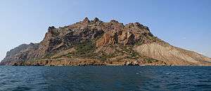
The Kara Dag ("Black Mount") is a volcanic rock formation which rises to a height of 577 meters between the Crimean coastal town of Koktebel and the Otuzka River valley. It has been the site of a marine biological station since the early 20th century. Some 2874 ha of coastline and 809 ha of coastal waters have been protected as the Karadag Nature Reserve since 1979. The littoral is rich in picturesque cliffs such as the Devil's Gate. The best views of the Black Mount are from Koktebel and Kurortnoye.
| Kara Dag | |
|---|---|
 | |
| Highest point | |
| Elevation | 577 m (1,893 ft) |
| Coordinates | |
| Geography | |
.jpg) Kara Dag | |
| Country | |
| Parent range | Crimean Mountains |
| Geology | |
| Age of rock | 172.8 ± 4.5 Ma [1] |
See also
References
- "Popov, D. V., Brovchenko, V. D., Nekrylov, N. A., et al.(2019). Removing a mask of alteration: Geochemistry and age of the Karadag volcanic sequence in SE Crimea. Lithos, 324, 371-384". doi:10.1016/j.lithos.2018.11.024. Cite journal requires
|journal=(help)
External links
- http://www.blacksea-crimea.com/Places/Kara-Dag.html
- https://web.archive.org/web/20070711091427/http://www.tourism.crimea.ua/eng/dostoprim/parks/reserves/kardagvr/index.html
- http://www.tour.crimea.com/ENGLISH/NAVIGATOR/ABOUT_CRIMEA/geography.shtml
| Mountains |  | |
|---|---|---|
| Passes | ||
| Landforms | ||
| Palaces | ||
| Fortresses | ||
| Ancient cities | ||
| Others | ||
This article is issued from Wikipedia. The text is licensed under Creative Commons - Attribution - Sharealike. Additional terms may apply for the media files.