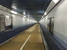
Kanmon Tunnel
The Kanmon Railway Tunnel, Kanmon Roadway Tunnel, and Shin-Kanmon Tunnel are undersea tunnels crossing the Kanmon Straits between Shimonoseki, Yamaguchi, and Kitakyushu, Fukuoka in western Japan. When opened in 1942, the railway tunnel provided the first direct link between Honshu and Kyushu, two of Japan's four main islands.[1]
Kanmon Railway Tunnel
| Overview | |
|---|---|
| Line | San'yō Main Line |
| Location | Honshu-Kyushu |
| Operation | |
| Opened | 1942 |
| Operator | JR Kyushu |
| Character | Passenger and freight |
| Technical | |
| Line length | 3,604 m (11,824 ft)/ 3,614 m (11,857 ft) |
The Kanmon Railway Tunnel (関門鉄道トンネル, kanmon tetsudō tonneru) was the first undersea tunnel in Japan. It goes underneath the Kanmon Straits, connecting the islands of Honshu and Kyushu. It is an important link in the Japanese rail network. Its construction began in 1936, and it was completed in November 1942, during the Pacific War. The Honshu-bound tunnel is 3,604 m (11,824 ft) long, the Kyushu-bound tunnel is 3,614 m (11,857 ft). Track gauge is 1.067 m (3 ft 6.0 in), and its electric power supply is at 1,500 volts DC.
Near the end of the Pacific War the Allies planned to blow up the two tunnels with 50,000 pounds of explosives as part of the invasion of Japan. 250 Office of Strategic Services agents trained for the task, but the surrender of Japan occurred before they were needed.[2]
The Kyushu Railway Company (JR Kyushu) assumed ownership of this tunnel following the breakup of the Japanese National Railways system in 1987.
Coordinates
- Shimonoseki entrance: 33°56′03″N 130°55′00″E
- Moji entrance: 33°54′37″N 130°56′11″E
Kanmon Roadway Tunnel
 | |
| Overview | |
|---|---|
| Line | |
| Location | Honshu-Kyushu |
| Coordinates | 33°57′48.6″N 130°57′33.6″E |
| Operation | |
| Opened | 1958 |
| Technical | |
| Line length | 3,461 m (11,355 ft) |
| Lowest elevation | 58 m below sea level |

The Kanmon Roadway Tunnel (関門国道トンネル, kanmon kokudō tonneru) carries National Route 2 under the Kanmon Straits. It is the longest undersea road in the world. It opened in 1958. The overall length is 3,461 meters, and it is 58 meters below sea level at the deepest point. The endpoints are in Shimonoseki, Yamaguchi and Moji-ku, Kitakyushu.
Work on the Kanmon Roadway Tunnel began in 1937, but was halted in 1939 by World War II. Work resumed in 1952, and the tunnel was officially opened on March 9, 1958. The event was marked by a Japanese commemorative postage stamp. Major repairs were conducted in 2008.
Under terms of Article 46.3 of Road Act, driving by vehicles that carry dangerous goods are either prohibited or limited strictly.
Coordinates
- Shimonoseki entrance for cars: 33°58′30″N 130°56′51″E
- Shimonoseki entrance for pedestrians and bicycles: 33°57′55″N 130°57′22″E
- Moji entrance for cars: 33°57′05″N 130°58′08″E
- Moji entrance for pedestrians and bicycles: 33°57′41″N 130°57′47″E
Shin-Kanmon Tunnel
| Overview | |
|---|---|
| Line | Sanyō Shinkansen |
| Location | Honshu-Kyushu |
| Operation | |
| Opened | 1975 |
| Operator | JR West |
| Character | Passenger |
| Technical | |
| Line length | 18.713 km (11.628 mi) |
| Track gauge | 1,435 mm (4 ft 8 1⁄2 in) |
The more modern Shin-Kanmon Tunnel (新関門トンネル, shin-kanmon tonneru) is 18.713 km long and carries the Sanyo Shinkansen high-speed railway line under the Kanmon Straits.
Coordinates
- Shimonoseki entrance: 34°00′11″N 130°56′53″E
- Moji entrance: 33°52′58″N 130°53′55″E
External links
- Kanmon Tunnel Footpath on Kitakyushu City Tourist Information website
- Kanmon Pedestrian Tunnel on Kyushu Tourism Promotion Organization website
References
- Smith, Roderick A. (2003). "The Japanese Shinkansen". The Journal of Transport History. Imperial College, London. 24/2 (2): 222–236. doi:10.7227/TJTH.24.2.6.
- Breuer, William B. (2003). The Spy Who Spent the War in Bed: And Other Bizarre Tales from World War II. Hoboken, New Jersey: Wiley. pp. 200. ISBN 0-471-26739-2.