Kala Pahar
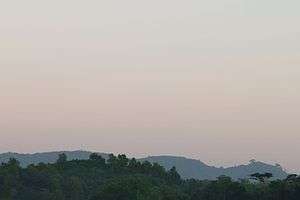
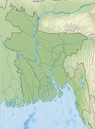
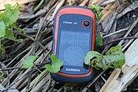
Kala Pahar is the highest peak of Greater Sylhet. It is also the highest point of the northern part of Bangladesh. Located near Robir bazar of Kulaura upazila in Moulvibazar district, it is only 3–4 hours trekking distance from Azgarabad Tea Estate. This peak is also accessible from Rajki tea estate near Fultola bazar of Juri upazila. The hill range of Kala Pahar is locally known as Longla Range. 'Kala Pahar' is the local name of the highest peak. According to Bangladesh Geographic society this hill is also known as 'Hararganj pahar'. In Bengali language 'hill' word means 'Pahar'. Situated in the north-eastern part of the country 60% of the range is in Bangladesh and the rest is in the Northern Tripura state of India. In Tripura, part of this hill is known as Raghunandan pahar. The famous ancient religious archaeological site of India ‘Unakoti’ lies at the foot of this hill. Kala Pahar is about 1,100 feet high from the sea level. In November 2015, few members of a local adventure group of Bangladesh BD Explorer explored this peak and measured the highest point as 1,098 feet[2] (from sea level) with Garmin handheld gps. The view from the peak is awesome. During Autumn season,if the sky is clear one can observe the blue water of Hakaluki haor(Largest haor of Bangladesh) from the high point of Kala Pahar. There are few Khasi establishments adjacent to this hill. Like Nunchora punji, Panaichora punji, Putichora punji and Baigonchora punji.
| Kala Pahar | |
|---|---|
 Kala Pahar | |
| Highest point | |
| Elevation | 334.67[1] m (1,098.0 ft) |
| Coordinates | 24°24′35″N 92°4′47″E |
| Geography | |
 Kala Pahar Geo position of Kala Pahar | |
| Location | Kulaura,Moulvibazar,Sylhet division. |
| Parent range | Longla / Hararganj hill. |
| Geology | |
| Mountain type | Hill |
This place is slowly but surely becoming very popular to the nature lovers to visit as adventure day trip.[3]
Location:  Kulaura,Moulvibazar,Sylhet division.
Range:     Longla / Hararganj hill.
Elevation: 1,098 feet.(Gps accuracy +/-3 m)[4]
Position:  24°24.586'N
           92°04.792'E [5]
Elevation Measured By: BD Explorer
See also
- Geography of Bangladesh
- List of countries by highest point
- List of mountains of Bangladesh
References
- http://www.wikiloc.com/wikiloc/view.do?id=11491114
- http://www.wikiloc.com/wikiloc/view.do?id=11491114
- "Archived copy". Archived from the original on 2016-12-29. Retrieved 2016-07-23.CS1 maint: archived copy as title (link)
- http://www.wikiloc.com/wikiloc/imgServer.do?id=6999341
- http://www.wikiloc.com/wikiloc/view.do?id=11491114
External links
Capital: Moulvibazar | ||
| Upazilas | ||
| Constituencies | ||
| Attractions and sites |
| |
| Mosques | ||
| Rivers | ||
| Inhabited areas | ||
| Educational institutions |
| |
| Transport | ||
| History | ||