Jolietville, Indiana
Jolietville is a neighborhood of Westfield, Indiana, in Washington Township, Hamilton County, Indiana. It was formerly an unincorporated community, but was annexed by Westfield in the late 2000s or early 2010s.[3]
Jolietville | |
|---|---|
Town | |
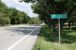 Looking east toward Jolietville along Indiana State Road 32 | |
 Jolietville | |
| Coordinates: 40°02′31″N 86°13′52″W | |
| Country | United States |
| State | Indiana |
| County | Hamilton |
| Township | Washington |
| Elevation | 919 ft (280 m) |
| ZIP code | 46074 |
| FIPS code | 18-38844[1] |
| GNIS feature ID | 437071[2] |
Geography
Jolietville is located at 40°02′31″N 86°13′52″W. The community is located at the intersection of Indiana State Road 32 and Joliet Road, just east of the Indianapolis Executive Airport.
gollark: ... I have forgotten the new feature I was going to add, alas.
gollark: Anyway, if you can figure out *how to* exploit that, enjoy.
gollark: I think PotatOS does some of that itself anyway.
gollark: Did I just now say now twice in one clause?
gollark: PotatOS now has the `chaos` RNG now, but that's not actually used, and is... probably worse.
References
- "U.S. Census website". United States Census Bureau. Retrieved 2008-01-31.
- "Jolietville, Indiana". Geographic Names Information System. United States Geological Survey. Retrieved 2009-10-17.
- 2012 Boundary and Annexation Survey (BAS): Westfield city, IN, United States Census Bureau.
Municipalities and communities of Hamilton County, Indiana, United States | ||
|---|---|---|
| Cities | Map of Indiana highlighting Hamilton County | |
| Towns | ||
| Townships | ||
| Unincorporated communities | ||
| Footnotes | ‡This populated place also has portions in an adjacent county or counties | |
This article is issued from Wikipedia. The text is licensed under Creative Commons - Attribution - Sharealike. Additional terms may apply for the media files.