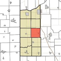
Jackson Township, Newton County, Indiana
Jackson Township is one of ten townships in Newton County, Indiana. As of the 2010 census, its population was 382 and it contained 178 housing units.[3]
Jackson Township | |
|---|---|
 | |
| Coordinates: 40°57′12″N 87°20′36″W | |
| Country | United States |
| State | Indiana |
| County | Newton |
| Government | |
| • Type | Indiana township |
| Area | |
| • Total | 36.65 sq mi (94.9 km2) |
| • Land | 36.62 sq mi (94.8 km2) |
| • Water | 0.03 sq mi (0.08 km2) |
| Elevation | 712 ft (217 m) |
| Population (2010) | |
| • Total | 382 |
| • Density | 10.4/sq mi (4.0/km2) |
| Time zone | UTC-6 (Central (CST)) |
| • Summer (DST) | UTC-5 (CDT) |
| Area code(s) | 219 |
| FIPS code | 18-37242[2] |
| GNIS feature ID | 453457 |
Geography
According to the 2010 census, the township has a total area of 36.65 square miles (94.9 km2), of which 36.62 square miles (94.8 km2) (or 99.92%) is land and 0.03 square miles (0.078 km2) (or 0.08%) is water.[3]
Cities and towns
gollark: I mean, as far as I know people act vaguely toward their self-image.
gollark: It kind of does ish.
gollark: Okay, fine, everyone is my alt except garbage2.
gollark: It's a monoid in the category of endofunctors.
gollark: Not you, garbage3.
References
- "US Board on Geographic Names". United States Geological Survey. 2007-10-25. Retrieved 2008-01-31.
- "U.S. Census website". United States Census Bureau. Retrieved 2008-01-31.
- "Population, Housing Units, Area, and Density: 2010 - County -- County Subdivision and Place -- 2010 Census Summary File 1". United States Census. Archived from the original on 2020-02-12. Retrieved 2013-05-10.
This article is issued from Wikipedia. The text is licensed under Creative Commons - Attribution - Sharealike. Additional terms may apply for the media files.