Interstate 180 (Pennsylvania)
Interstate 180 (I-180) is a spur highway that connects Williamsport, Pennsylvania to Interstate 80 near Milton, Pennsylvania. The length of the highway is 28.85 miles (46.43 km). It was also the designation of present-day Interstate 176 between Morgantown, Pennsylvania and Reading, when the Pennsylvania Turnpike carried the "I-80S" designation in the 1960s. It is signed as an east–west route for its entire length, even though half of the route runs north–south.
| ||||
|---|---|---|---|---|
%26groups%3D_4962f45abae3be2262f4f17c04be9acaf22bf66e.svg)
I-180 highlighted in red | ||||
| Route information | ||||
| Auxiliary route of I-80 | ||||
| Maintained by PennDOT | ||||
| Length | 28.85 mi[1] (46.43 km) | |||
| Existed | January 1984[2]–present | |||
| Major junctions | ||||
| West end | ||||
| ||||
| East end | ||||
| Location | ||||
| Counties | Lycoming, Northumberland | |||
| Highway system | ||||
| ||||

Route description
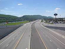
I-180 begins along the banks of the West Branch Susquehanna River in Williamsport, at an interchange with U.S. Route 15 (US 15) and US 220. The highway begins running concurrently along these routes.
At exit 27A, US 15 leaves the overlap running south across the Carl E. Stotz Memorial Little League Bridge, and I-180 continues eastward, still concurrent with US 220 northbound. From there, I-180 runs along the West Branch Susquehanna River until the highway reaches the eastern suburbs of Williamsport, where US 220 leaves the Interstate via exit 15.
From US 220 to the eastern terminus, I-180 is aligned north–south, though the highway is signed east–west. I-180 terminates at an interchange with I-80, and the freeway continues as PA 147.
History
I-180 was designated in January 1984 and was signed concurrently with US 220 between US 15 in Williamsport and Pennsdale and replaced PA 147 between US 220 in Pennsdale and I-80 near Milton.[2]
Exit list
| County | Location | mi[3] | km | Exit | Destinations | Notes |
|---|---|---|---|---|---|---|
| Lycoming | Williamsport | – | Continuation beyond western terminus | |||
| 28.84 | 46.41 | 29 | West end of concurrency with US 15 | |||
| 27.9 | 44.9 | 28 | Maynard Street – Pennsylvania College of Technology | |||
| 27.7 | 44.6 | 27B | Hepburn Street / Via Bella – Lycoming College, Peter J. McGovern Little League Museum | Eastbound exit and westbound entrance | ||
| 26.8 | 43.1 | 27A | East end of concurrency with US 15; single-point urban interchange | |||
| 26.5 | 42.6 | 26 | Basin Street / Via Bella – Lycoming College, Peter J. McGovern Little League Museum | Westbound exit and eastbound entrance | ||
| Loyalsock | 25.3 | 40.7 | 25 | Commerce Park, Faxon | ||
| 24.0 | 38.6 | 23 | Third Street / Warrensville Road – Warrensville, Montoursville | Signed as exits 23B (Warrensville Road) and 23A (Third Street) eastbound | ||
| Montoursville | 21.7 | 34.9 | 21 | PA 87 begins north, Loyalsock Avenue south | ||
| 20.4 | 32.8 | 20 | Fairfield Road | |||
| Muncy Township | 16.9 | 27.2 | 17 | Lycoming Mall Road | ||
| 15.5 | 24.9 | 15 | East end of US 220 concurrency | |||
| Muncy Creek Township | 12.8 | 20.6 | 13 | |||
| 10.6 | 17.1 | 10 | Main Street | Westbound exit and eastbound entrance | ||
| Northumberland | Delaware Township | 5.6 | 9.0 | 5 | ||
| 1.1 | 1.8 | 1 | McEwensville, Watsontown | |||
| Turbot Township | 0 | 0.0 | I-80 exit 212 | |||
| – | Continuation beyond eastern terminus | |||||
1.000 mi = 1.609 km; 1.000 km = 0.621 mi
| ||||||
See also

References
- "Route Log - Auxiliary Routes of the Eisenhower National System Of Interstate and Defense Highways - Table 2". Federal Highway Administration. Retrieved 5 October 2014.
- "Section of Rt. 147 Becomes Rt. 180". The Daily Item. Sunbury, Pennsylvania. January 5, 1984. p. 9. Retrieved April 18, 2019 – via Newspapers.com.

- Google (25 November 2017). "Interstate 180 (Pennsylvania)" (Map). Google Maps. Google. Retrieved 25 November 2017.
| ||
| ||