Indiana State Road 446
State Road 446 (SR 446) is a short highway in Lawrence and Monroe counties in southern Indiana, United States. Though it is an even-numbered route, it is actually a north–south highway.
| ||||
|---|---|---|---|---|
 | ||||
| Route information | ||||
| Maintained by INDOT | ||||
| Length | 23.550 mi[1] (37.900 km) | |||
| Major junctions | ||||
| North end | ||||
| South end | ||||
| Location | ||||
| Counties | ||||
| Highway system | ||||
| ||||

Route description
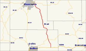
SR 446 connects State Road 46 on the east side of Bloomington with U.S. Route 50 in eastern Lawrence County. It passes over a causeway over Lake Monroe and through the Hoosier National Forest.
Major intersections
| County | Location | mi[1] | km | Destinations | Notes |
|---|---|---|---|---|---|
| Lawrence | Shawswick Township | 0.000 | 0.000 | Southern terminus of SR 446 | |
| Pleasant Run Township | 4.094 | 6.589 | |||
| Monroe | Bloomington | 23.550 | 37.900 | Northern terminus of SR 446 | |
| 1.000 mi = 1.609 km; 1.000 km = 0.621 mi | |||||
gollark: `string.dump` and parsing it, but you're probably doing something wrong or really weird.
gollark: Oh. That. `debug.getinfo`.
gollark: The what?
gollark: You can do that, it'll work fine.
gollark: <@318817623590830080> why not just directly send the string of DFPWM data?
References
- Indiana Department of Transportation (July 2016). Reference Post Book (PDF). Indianapolis: Indiana Department of Transportation. Retrieved February 2, 2017.
This article is issued from Wikipedia. The text is licensed under Creative Commons - Attribution - Sharealike. Additional terms may apply for the media files.