Indiana State Road 445
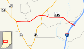
State Road 445 (SR 445) is a short connector route, just 2.807 miles (4.517 km) long, in eastern Greene County, just north of the small town of Cincinnati. It connects SR 54, SR 45, and I-69 (Exit 104).
| ||||
|---|---|---|---|---|
 | ||||
| Route information | ||||
| Maintained by INDOT | ||||
| Length | 2.807 mi[1] (4.517 km) | |||
| Major junctions | ||||
| West end | ||||
| East end | ||||
| Location | ||||
| Counties | Greene | |||
| Highway system | ||||
| ||||

Route description
SR 445 begins at SR 54 with a flashing light, near the Greene County Inn (also a cafe). It then runs east to a four-way intersection where it meets SR 45. It then continues east, coming to its eastern terminus at exit 104 on Interstate 69 (I-69).
History
SR 445's original eastern terminus was a stop sign with SR 45. On December 9, 2015, I-69 opened, and SR 445 was extended east to I-69 Exit 104.
Major intersections
The entire route is in Center Township, Greene County.
| mi[1] | km | Destinations | Notes | ||
|---|---|---|---|---|---|
| 0.000 | 0.000 | Western terminus of SR 445 | |||
| 1.394 | 2.243 | Former eastern terminus of SR 445 | |||
| 2.807 | 4.517 | Exit 104; Eastern terminus of SR 445 | |||
| 1.000 mi = 1.609 km; 1.000 km = 0.621 mi | |||||
gollark: Maybe it just automatically does that.
gollark: > there is still someone able to see the messageWhy would they bother reading the responses?
gollark: Also, again, these are bots, *nobody* sane would *manually* try and scam tons of people.
gollark: The "grabs IPs" thing sounds very script kiddie, see.
gollark: Also, the "grab your IP" thing is very 1337 h4xx0r.
References
- Indiana Department of Transportation (July 2015). Reference Post Book (PDF). Indianapolis: Indiana Department of Transportation. Retrieved January 29, 2017.
External links
This article is issued from Wikipedia. The text is licensed under Creative Commons - Attribution - Sharealike. Additional terms may apply for the media files.