Illinois Route 184
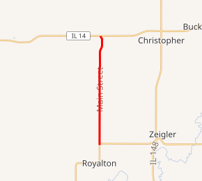
Illinois Route 184 is a 5.87-mile (9.45 km) state road in the southern portion of the U.S. state of Illinois located entirely within Franklin County.[1] It runs from Illinois Route 149 in Royalton north to Illinois Route 14 in Mulkeytown. Route 184 is maintained by the Illinois Department of Transportation.
| ||||
|---|---|---|---|---|
| Main Street | ||||

IL 184 highlighted in red | ||||
| Route information | ||||
| Maintained by IDOT | ||||
| Length | 5.87 mi[1] (9.45 km) | |||
| Existed | 1924[2]–present | |||
| Major junctions | ||||
| South end | ||||
| North end | ||||
| Location | ||||
| Counties | Franklin | |||
| Highway system | ||||
| ||||
Route description
Route 184 begins at an intersection with Route 149 in Six Mile Township north of Royalton. The route continues north through farmland, passing occasional buildings. It meets County Route 14 before intersecting County Route 30 at the border of Tyrone Township. Route 184 continues north to Mulkeytown, where it terminates at Illinois Route 14; the road continues northward as County Route 38. Route 184 is a two-lane surface road for its entire length.[3][4]
History
Route 184 was established in 1924 along its current route.[2] It was first marked on the 1929 Illinois highway map.[5]
Major intersections
The entire route is in Franklin County.
| Location | mi[4] | km | Destinations | Notes | |
|---|---|---|---|---|---|
| Six Mile Township | 0.00 | 0.00 | Southern terminus | ||
| Mulkeytown | 5.87 | 9.45 | Northern terminus | ||
| 1.000 mi = 1.609 km; 1.000 km = 0.621 mi | |||||
References
- Illinois Technology Transfer Center (2006). "T2 GIS Data". Retrieved 8 November 2007.
- Illinois Blue Book, 1923–1924. State of Illinois. 1923. p. 268. Retrieved 8 January 2011.
- Franklin County General Highway Map (PDF) (Map). Illinois Department of Transportation. 1997. Retrieved 8 January 2011.
- Google (8 January 2011). "Overview map of State Highway 184" (Map). Google Maps. Google. Retrieved 8 January 2011.
- "1929 Official Illinois Highway Map". Illinois Digital Archives. Illinois State Library. Retrieved 9 November 2010.
