Idaho State Highway 39
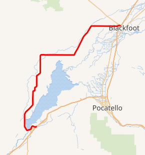
State Highway 39 (SH-39) is a 52.924-mile-long (85.173 km) state highway located in Power and Bingham counties in Idaho. SH-39 runs from its southern terminus at Interstate 86 (I-86) in American Falls to its northern terminus at U.S. Route 26 (US-26) in Blackfoot. Between the two cities, it passes through the city of Aberdeen and the communities of Springfield and Pingree.
| ||||
|---|---|---|---|---|

SH-39 highlighted in red | ||||
| Route information | ||||
| Maintained by ITD | ||||
| Length | 52.924 mi[1] (85.173 km) | |||
| Major junctions | ||||
| South end | ||||
| North end | ||||
| Highway system | ||||
| ||||
Route description
Idaho State Highway 39 begins at an interchange with Interstate 86 next to the American Falls Airport. The highway proceeds west, bypassing the community of American Falls. The road travels along the American Falls Dam, before bending northward, and traveling parallel to American Falls Reservoir. The highway continues, bending northeast, before bending back northward, and passing through the community of Aberdeen. The roadway continues north, before traveling northeast for a short distance, and turning north again. The route continues north, before bending eastward and proceeding. The highway proceeds eastward for several miles, before bending northeastward. The highway continues northeastward, and, after a long distance, passes the Rockford Municipal Airport. The road bends eastward, passing through the community of Moreland. The highway continues eastward to its eastern terminus, an intersection with U.S. Route 26.[2]
Major intersections
| County | Location | mi[1] | km | Destinations | Notes |
|---|---|---|---|---|---|
| Power | American Falls | 0.000 | 0.000 | Southern terminus | |
| Bingham | Blackfoot | 52.924 | 85.173 | Northern terminus | |
| 1.000 mi = 1.609 km; 1.000 km = 0.621 mi | |||||
References
- Idaho Transportation Department, Idaho milepoint log
- Google (January 29, 2013). "Overview Map of Idaho State Highway 39" (Map). Google Maps. Google. Retrieved January 29, 2013.
External links
![]()
