Hyōnosen-Ushiroyama-Nagisan Quasi-National Park
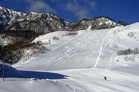
Hyōnosen-Ushiroyama-Nagisan Kokutei Kōen (氷ノ山後山那岐山国定公園) is a Quasi-National Park in Hyōgo Prefecture, Tottori Prefecture, and Okayama Prefecture, Japan.[1][2] It was founded on 10 April 1969 and has an area of 488.03 square kilometres (188.43 sq mi).[3][4][5]
| Hyōnosen-Ushiroyama-Nagisan Quasi-National Park | |
|---|---|
| 氷ノ山後山那岐山国定公園 | |
IUCN category V (protected landscape/seascape) | |
 | |
 Location of Hyōnosen-Ushiroyama-Nagisan Quasi-National Park in Japan | |
| Location | Kansai Region, Japan |
| Nearest city | Toyooka, Hyōgo Prefecture |
| Coordinates | 35°20′17″N 134°29′2″E |
| Area | 488.03 square kilometres (188.43 sq mi) |
| Established | April 10, 1969 |
| Governing body | Hyōgo Prefecture, Tottori Prefecture, Okayama Prefecture |
Overview
Hyōnosen-Ushiroyama-Nagisan Kokutei Kōen comprises three areas of the Chūgoku Mountains, a mountain range which forms the backbone of the Chūgoku region of western Japan and extends under the Pacific Ocean.[4] The park covers 48,803 hectares (120,590 acres): 25,200 hectares (62,000 acres) in Hyōgo Prefecture, 15,024 hectares (37,130 acres) in Okayama Prefecture, and 8,579 hectares (21,200 acres) in Tottori Prefecture.
Mountains
Important mountains of the park include:
- Mount Hyōno -- 1,510 metres (4,950 ft). Hyōgo and Tottori prefectures
- Mount Sobu -- 1,074 metres (3,524 ft). Hyōgo Prefecture
- Mount Mimuro -- 1,358 metres (4,455 ft). Hyōgo and Tottori prefectures
- Mount Ushiro -- 1,345 metres (4,413 ft). Hyōgo and Okayama prefectures
- Mount Nagi -- 1,255 metres (4,117 ft). Tottori and Okayama prefectures[4][5]
gollark: Aaaaand my server is not responding.
gollark: Oh, I can shut down ABR's esobot backup now?
gollark: !esowiki Embedded hq9+
gollark: ++help
gollark: !help
See also
| Wikimedia Commons has media related to Hyonosen-Ushiroyama-Nagisan Quasi-National Park. |
External links
- 氷ノ山後山那岐山国定公園, J-IBIS (in Japanese)
- The Hyonosen - Ushiroyama Nagisan Quasi National Park, World Database on Protected Areas.
References
- "氷ノ山後山那岐山国定公園". Ministry of the Environment. Archived from the original on 16 April 2014. Retrieved 10 May 2011.
- "丹後天橋立大江山/明治の森箕面/金剛生駒紀泉/氷ノ山後山那岐山". National Parks Association of Japan. Archived from the original on 4 August 2010. Retrieved 10 May 2011.
- "List of National Parks". Ministry of the Environment. Retrieved 10 May 2011.
- "氷ノ山後山那岐山国定公園" [Hyōnosen-Ushiroyama-Nagisan Kokutei Kōen]. Dijitaru daijisen (in Japanese). Tokyo: Shogakukan. 2012. OCLC 56431036. Archived from the original on August 25, 2007. Retrieved 2012-07-11.
- "氷ノ山後山那岐山国定公園" [Hyōnosen-Ushiroyama-Nagisan Kokutei Kōen]. Nihon Daihyakka Zensho (Nipponika) (in Japanese). Tokyo: Shogakukan. 2012. OCLC 153301537. Archived from the original on August 25, 2007. Retrieved 2012-07-10.
This article is issued from Wikipedia. The text is licensed under Creative Commons - Attribution - Sharealike. Additional terms may apply for the media files.
