Huveaune
The Huveaune (Occitan: Uveuna) is a small river in the Provence-Alpes-Côte d'Azur region of southeastern France. It is 48.4 kilometres (30.1 mi) long and flows through the communes of La Penne-sur-Huveaune, Nans-les-Pins, Saint-Zacharie, Plan-d'Aups-Sainte-Baume, Auriol, Roquevaire, Aubagne, and the metropolitan area of Marseille.[1]
| Huveaune | |
|---|---|
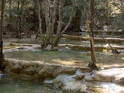 The Huveaune in springtime | |
| Native name | L'Huveaune (f) (French) |
| Location | |
| Country | France |
| Physical characteristics | |
| Source | |
| • location | Sainte-Baume |
| • elevation | 590 m (1,940 ft) |
| Mouth | |
• location | Mediterranean Sea |
| Length | 48.3 km (30.0 mi) |
| Basin size | 500 km2 (190 sq mi) |
| Discharge | |
| • average | 10 m3/s (350 cu ft/s) |
The Huveaune rises in the Castelette cave at 590 metres (1,940 ft) in the Sainte-Baume mountain range, and discharges into the Mediterranean Sea at Marseille.
References
- Sandre (2010). "La Huveaune (Y44-0400)". Eaufrance.fr (in French). Office national de l’eau et des milieux aquatiques. Retrieved 2 April 2012.
This article is issued from Wikipedia. The text is licensed under Creative Commons - Attribution - Sharealike. Additional terms may apply for the media files.