Hurricane Fausto (2008)
Hurricane Fausto was a strong Category 1 hurricane that had only minor effects on land during its life over the eastern Pacific basin. The seventh tropical depression, sixth named storm, and third hurricane of the 2008 Pacific hurricane season, Fausto formed out of a tropical wave on July 16. The storm gradually strengthened as it moved towards the west-northwest, becoming a minimal hurricane two days later. On July 19, Fausto turned towards the northwest as it continued to strengthen. The next day, while passing between the Mexican islands of Clarion and Socorro, the hurricane reached its peak intensity with winds of 90 mph (150 km/h) and a minimum pressure of 977 mbar (hPa; 28.85 inHg).
| Category 1 hurricane (SSHWS/NWS) | |
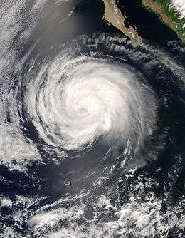
 Hurricane Fausto near peak intensity on July 20 | |
| Formed | July 16, 2008 |
|---|---|
| Dissipated | July 22, 2008 |
| Highest winds | 1-minute sustained: 90 mph (150 km/h) |
| Lowest pressure | 977 mbar (hPa); 28.85 inHg |
| Fatalities | None reported |
| Damage | Minimal |
| Areas affected | Clarion Island, Socorro Island, and Sinaloa |
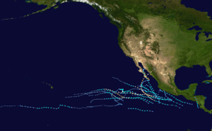
| Part of the 2008 Pacific hurricane season | |
Fausto steadily weakened throughout the following two days as it moved over progressively cooler waters. By July 21, the storm was downgraded to a tropical storm and a tropical depression the next day. Early on July 23, the depression lacked deep convection and degenerated into a remnant low pressure area. The low persisted for another day before dissipating over open waters. Hurricane Fausto had little effect on land, despite passing close to the islands of Clarion and Socorro where high winds, reaching hurricane-force on Socorro, were recorded. Moderate rainfall from the outer bands of the storm amounted to 1.9 in (50 mm) in the Mexican state of Sinaloa.
Meteorological history

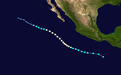
The origins of Hurricane Fausto were in a westward-traveling tropical wave that moved off the eastern coast of Africa on July 4. Little development occurred as the wave traversed the Atlantic basin. It entered the eastern Pacific basin on July 12 after crossing Central America and began to show signs of development the next day. The system westward movement became slightly erratic on July 14 as development slowed. The following day, the system became increasingly organized and a tropical depression, which was designated 07-E, formed about 550 mi (890 km) southeast of Acapulco, Mexico.[1] The depression maintained an area of deep convection around the center of circulation and was located within an area of moderate wind shear. An area of high pressure located over the southwestern United States was forecast to steer the system towards the northwest for most of its existence.[2] A mid-level ridge located to the north of the depression caused it to rapidly travel towards the west at 23 mph (37 km/h) for most of July 16.[1]
Shortly after being designated as a depression, 17-E was upgraded to a tropical storm and given the name Fausto.[1] Despite being partially exposed from convection, the system featured several banding features which supported a wind intensity of 40 mph (65 km/h).[3] As a large cyclone, Fausto slowly intensified,[1] with convection consolidating around the center the next day. The combination of relaxing wind shear and warm sea surface temperatures allowed the storm to intensify.[1][4] Later that day, the center of Fausto became exposed but a large band of deep convection surrounded the exposed low.[5] Early on July 18, a banding eye feature began to develop in the southern portion of the storm. Around this time, forward motion slowed[6] as it began to turn towards the northeast.[1] Later that day, a partial eyewall began to develop, indicating that Fausto had strengthened into a hurricane with winds reaching 75 mph (120 km/h).[7]

Shortly after being declared a hurricane, the eye started to appear on visible satellite imagery. With low wind shear and warm waters, further intensification was anticipated.[8] Very cold cloud tops with temperatures as low as –112 °F (–80 °C) surrounded the developing eye[9] allowing the storm to intensify. Strengthening stopped for most of July 19 and the first half of July 20.[1] That day, Fausto strengthened slightly as a ragged eye formed[10] while the storm passed between the islands of Clarion and Socorro. At this time, the hurricane reached its peak intensity with winds of 90 mph (150 km/h) and a minimum pressure of 977 mbar (hPa; 28.85 inHg).[1] Operationally, Fausto was assessed to have reached its peak intensity several hours later as a minimal Category 2 hurricane with winds of 100 mph (155 km/h) as the eye became better defined. However, the storm was located over 75 °F (24 °C) waters,[11] causing it to gradually weaken along with[1] diminishing convective activity.[12] Later that day, Fausto was downgraded to a tropical storm and further weakened to a tropical depression the next day. With little or no remaining convection, the system degenerated into a remnant low pressure area as it traveled towards the west-northwest. The remnants of Fausto dissipated on July 24, while located about 1,065 mi (1,715 km) west of Cabo San Lucas.[1]
Preparations and impact
The National Hurricane Center did not forecast Fausto to affect any major land areas during its existence. As such, no tropical cyclone advisories were issued.[1] The outer bands of Fausto produced moderate rainfall over portions of Sinaloa, Mexico, peaking at 1.9 in (50 mm).[13] Several hours before the center of Fausto passed between Clarion Island and Socorro Island, sustained winds on Clarion were recorded at 64 mph (103 km/h) with gusts to 94 mph (151 km/h). Nearby Socorro recorded sustained winds of 79 mph (129 km/h) with gusts to 109 mph (175 km/h). Little or no damage was recorded on the islands. The hurricane-force winds reported on Socorro was recorded as Fausto made its closest approach to the island about 115 mi (185 km) to the southwest. However, due to the distance from the center of Fausto, these winds are suspected to be overestimated.[1] Along the coastline of Mexico, waves up to 8 ft (2.4 m) were recorded in relation to Fausto.[14]
See also
- 2008 Pacific hurricane season
- Timeline of the 2008 Pacific hurricane season
- Other storms named Fausto
References
- John L. Beven II (November 19, 2008). "Hurricane Fausto Tropical Cyclone Report" (PDF). National Hurricane Center. Retrieved February 24, 2009.
- Franklin (July 16, 2008). "Tropical Depression 17E Discussion One". National Hurricane Center. Retrieved February 24, 2009.
- Avila (July 16, 2008). "Tropical Storm Fausto Discussion Three". National Hurricane Center. Retrieved February 24, 2009.
- Avila (July 17, 2008). "Tropical Storm Fausto Discussion Five". National Hurricane Center. Retrieved February 24, 2009.
- Knabb (July 17, 2008). "Tropical Storm Fausto Discussion Seven". National Hurricane Center. Retrieved February 24, 2009.
- Roberts and Rhome (July 18, 2008). "Tropical Storm Fausto Discussion Eight". National Hurricane Center. Retrieved February 24, 2009.
- Knabb (July 18, 2008). "Hurricane Fausto Discussion Ten". National Hurricane Center. Retrieved February 24, 2009.
- Knabb (July 18, 2008). "Hurricane Fausto Discussion Eleven". National Hurricane Center. Retrieved February 24, 2009.
- Roberts and Franklin (July 19, 2008). "Hurricane Fausto Discussion Eleven". National Hurricane Center. Retrieved February 24, 2009.
- Landsea and Knabb (July 20, 2008). "Hurricane Fausto Discussion Eighteen". National Hurricane Center. Retrieved February 24, 2009.
- Roberts and Pasch (July 21, 2008). "Hurricane Fausto Discussion Twenty-One". National Hurricane Center. Retrieved February 24, 2009.
- Landsea and Knabb (July 21, 2008). "Hurricane Fausto Discussion Twenty-Two". National Hurricane Center. Retrieved February 24, 2009.
- José Angel Estrada (July 20, 2008). "Huracán "Fausto" dejará lluvias moderadas en Sinaloa: CAADES" (in Spanish). El Sol de Sinaloa. Retrieved February 24, 2009.
- Staff Writer (July 21, 2008). "July 21, 2008 Weather Bulletin" (PDF) (in Spanish). General Directorate of Merchant Shipping. Archived from the original (PDF) on July 22, 2011. Retrieved June 13, 2009.
External links
| Wikimedia Commons has media related to Hurricane Fausto (2008). |
