Huaura Province
Huaura is one of nine provinces of the Department of Lima on the Pacific coast of Peru. It has a population of about 180,000 inhabitants. It is bordered by the province of Barranca and the Ancash Region in the north, the provinces of Cajatambo and Oyón and the Pasco Region in the east, the province of Huaral in the south and the Pacific Ocean in the west. The capital of the province is Huacho.
Huaura | |
|---|---|
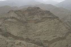 The archaeological site of Acaray in the Huaura Province | |
 Flag  Coat of arms | |
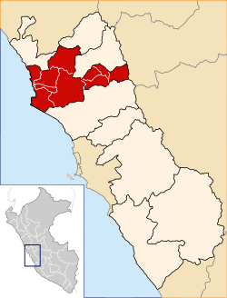 Location of Huaura in the Lima Region | |
| Country | Peru |
| Region | Lima |
| Capital | Huacho |
| Government | |
| • Mayor | Crispulo Eddie Jara Salazar (2019-2022) |
| Area | |
| • Total | 4,891.92 km2 (1,888.78 sq mi) |
| Population | |
| • Total | 227,685 |
| • Density | 47/km2 (120/sq mi) |
| UBIGEO | 1501 |
Geography
Some of the highest mountains of the province are listed below:[1]
- Anta Chuku
- Anta Ñawin
- Chunta
- Churinqucha
- Chururu
- Chururuyuq
- Ch'ura
- Inka Pukyu
- Mankha Ukru
- Mataqucha
- Muruqucha
- Pachan Wallqa
- Pari Chuku
- Puka Parya
- Puka Tampu
- Phiri Uya
- Qawi
- Wamanripa
- Waqra Punta
- Wathiyaqucha
- Yana Uqhu
- Yuraq Allpa
- Yuraq Punta
Political division
The 4,891.92 square kilometres (1,888.78 sq mi) is divided into twelve districts:
- Huacho (seat)
- Ambar
- Caleta
- Checras
- Hualmay
- Huaura
- Leoncio Prado
- Paccho
- Santa Leonor
- Santa María
- Sayán
- Vegueta
gollark: Although https://casket.tmpim.pw/ appears to not work.
gollark: Neat.
gollark: I switched from caddy v1 to nginx some time ago because they were pushing caddy v2 a lot, but it was actually bad.
gollark: Sure.
gollark: I will soon be initiating joining. None will be safe.
See also
References
- escale.minedu.gob.pe - UGEL map of the Huaura Province (Lima Region)
This article is issued from Wikipedia. The text is licensed under Creative Commons - Attribution - Sharealike. Additional terms may apply for the media files.