Huaping Islet
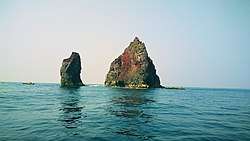
Huaping Islet[2] (Chinese: 花瓶嶼; pinyin: Huāpíng Yǔ), Taiwanese Hokkien: (Chinese: 花矸嶼; Pe̍h-ōe-jī: Hoe-kan-sū), also known as Kangjiao Yu ('sedan islet')[2], Hua-pʻing Hsü[5], Kahei-sho,[6] and Huaping Yu[7], is an 0.0308 km2 (0.0119 sq mi)[2][4] high island[4] in Zhongzheng District, Keelung, Taiwan located in the East China Sea.[8] The islet is 180 m (590 ft) long and 80 m (260 ft) wide with an elevation of 51 m (167 ft)[4]. 'Pyroxene and andesite are the major rock types of the islet. The entire islet is covered with metallic volcanic debris which has turned purplish red (bordeaux), purple, green, brass (yellowish) and iron grey after oxidation.'[2] Along with the nearby Pengjia Islet and Mianhua Islet, Huaping Islet is considered of strategic importance to Taiwan.[3]
| Native name: 花瓶嶼 (Mandarin), 花矸嶼 (Hokkien) | |
|---|---|
 Huaping Islet | |
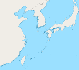 Huaping Islet Location in the East China Sea | |
| Geography | |
| Location | In the East China Sea north of Taiwan Island, part of Zhongzheng, Keelung, Taiwan[1][2][3] |
| Area | 0.0308 km2 (0.0119 sq mi)[2][4] |
| Administration | |
Republic of China (Taiwan) | |
| Province | Taiwan (streamlined) |
| Provincial city | Keelung |
| District | Zhongzheng |
| Additional information | |
| Time zone | |
History
On March 18, 1996, the Mianhua Islet and Huaping Islet Wildlife Preservation Area (棉花嶼、花瓶嶼野生動物保護區) was established.[4]
Due to the effects of Typhoon Maria (2018), part of the middle of the island crumbled off. The earlier single-humped camel shape became more like the shape of a double-humped camel.[4][9]
On October 28, 2019, the ship Hsieh-chien 168 (協建168) was sunk after striking rocks in the waters near Huaping Islet.[10]
Gallery
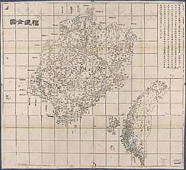 Map including Huaping Islet (labeled as 花瓶㠘)
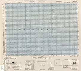 Map of Huaping Islet (labeled as KAHEI-SHO) and surrounding area (AMS, 1944)
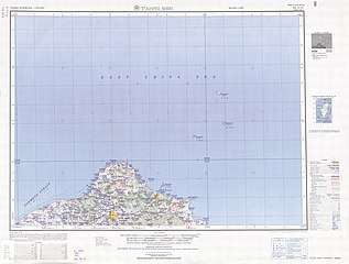 Map including Huaping Islet (labeled as Hua-pʻing Hsü (Kahei-sho) 花瓶嶼) (AMS, 1950)
 Map including Huaping Islet (labeled as Hua-pʻing Hsü) (1962)
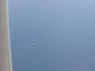 Huaping Islet from above
References
- 今日中正 [Today's Zhongzheng]. 基隆市中正區公所. Retrieved 23 April 2019.
3.本區北面面臨太平洋,並包括有和平島、彭佳嶼、基隆嶼、棉花嶼、花瓶嶼等島嶼自然地理景觀豐富
- "Beautiful Scenery". Keelung City Government. Retrieved 23 April 2019.
Pinnacle (Huaping Islet)
- "Pengjia Islet gets rare attention from Ma's visit". GlobalSecurity.org. 7 September 2012.
The normally obscure outcrop, which falls administratively under Keelung City, is one of three islets off of Taiwan's northern coast -- the others are Mianhua Islet and Huaping Islet -- considered to be of strategic importance to the country.
- 棉花嶼、花瓶嶼野生動物保護區. Forestry Bureau (in Chinese). 17 January 2019. Retrieved 24 September 2019.
由一個51公尺高之小島與數個小岩礁形成,面積約3.08公頃,{...}棉花嶼、花瓶嶼為各自獨立於基隆外海之火山島,{...}主島嶼之東側有一大裂罅,將嶼切分為二部。
- HarperCollins Atlas of the World. Italy: HarperCollins. 1998. pp. 51, 169. ISBN 0004489225 – via Internet Archive.
Hua-pʻing Hsü{...}51 H3 Hua-pʻing Hsü i. Taiwan
- http://legacy.lib.utexas.edu/maps/ams/taiwan/txu-oclc-6557994-ng51-10-450.jpg
- Britannica World Atlas. 1967. p. 58.
Huaping Yu
- 記者盧賢秀、黃旭磊、徐義平,"北方三島海域 將設國家公園"存档副本 (in Chinese). Liberty Times. Archived from the original on 2010-11-02. Retrieved 2018-08-04.
台灣北方海域有三座孤立的小島─彭佳嶼、棉花嶼和花瓶嶼 ,
- 記者盧賢秀、黃旭磊、徐義平/綜合報導, "北方三島海域 將設國家公園""Huaping Islet Falls Apart Single Hump Camel Becomes Double Hump" 花瓶嶼崩塌 單峰駝變雙峰 (in Chinese). Liberty Times. Retrieved 2018-08-04.
7月受瑪莉亞颱風過境影響,垮下一大片,崩裂成U型;背面原本像單峰駱駝,颱風過後也變成「雙峰」,外貌徹底改觀,未來甚至可能會一分為二,變成兩座小島。
- 吳康瑋 (29 October 2019). 花瓶嶼爆船難 價值「千萬」船隻完全滅頂 [Shipwreck at Huaping Islet- A ship worth 'tens of millions' is sunk] (in Chinese). China Times. Retrieved 20 January 2020.
External links
- 2018 8 8台語i會通.風颱掃過! 基隆"花矸嶼"單峰變雙峰駱駝 ('8 Aug 2018 I can use Taiwanese. Typhoon sweeps by! Keelung's Huaping Islet Changed from a Single-humped Camel to a Double-humped Camel') (in Min Nan Chinese)
| Wikimedia Commons has media related to Huaping Islet. |