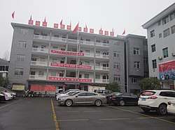
Huangzhou, Xinhuang
Huangzhou (simplified Chinese: 晃州镇; traditional Chinese: 晃州鎮; pinyin: Huǎngzhōu Zhèn) is an urban town and the county seat of Xinhuang Dong Autonomous County in Hunan, China. As of the 2015 census it had a population of 75,600 and an area of 203.17-square-kilometre (78.44 sq mi). The seat of local government is at Dadongping Village (大洞坪村).[1]
Huangzhou Town 晃州镇 | |
|---|---|
 Government Building of Huangzhou Town. | |
 Huangzhou Town Location in Hunan | |
| Coordinates: 27°22′33″N 109°10′23″E | |
| Country | People's Republic of China |
| Province | Hunan |
| Prefecture | Huaihua |
| Autonomous county | Xinhuang Dong Autonomous County |
| Area | |
| • Total | 203.17 km2 (78.44 sq mi) |
| Population (2015) | 75,600 |
| Time zone | UTC+8 (China Standard) |
| Postal code | 419299 |
| Area code(s) | 0745 |
History
The town is located in the northwest of the county, it was reformed to merge Xinlong Town (兴隆镇), Fangjiatun Township (方家屯乡), Dawanluo Township (大湾罗乡) and the Huangzhou Town on November 19, 2015. The seat of local government is at Dadongping Village (大洞坪村).[1]
Administrative division
As of 2015, the town is divided into seven communities and 56 villages.[2]
Geography
The Wushui River (潕水) winds through the town.[3]
There are two reservoirs in the town, namely the Yangjia'ao Reservoir (杨家坳水库) and Banxi Reservoir (半溪水库).[3]
There are a number of popular mountains located immediately adjacent to the townsite which include Mount Lengfengpo (冷风坡; 663-metre (2,175 ft)); Mount Wanbao (万宝山; 636-metre (2,087 ft)); and Mount Gunmapo (滚马坡; 916.7-metre (3,008 ft)).[3]
Economy
The local economy is primarily based upon agriculture and local industry.
Transport
The town is connected to three highways: the G60 Shanghai–Kunming Expressway and National Highway G320, both head east to Zhijiang Dong Autonomous County and west to Yuping Dong Autonomous County.[4] And the Provincial Highway S232 passes across the town north to south.[4]
The Shanghai–Kunming high-speed railway is a high-speed railway passes across the town northeast to southwest.[4]
References
- 湖南省民政厅关于同意新晃县乡镇区划调整方案的批复》(湘民行发〔2015〕50号). |website=rednet.cn |date=2015-12-04}}
- 怀化撤并93个乡镇,你家乡变了没 [Huaihua abolished and merged 93 townships, has your hometown changed?]. hunan.voc.com.cn (in Chinese). 3 December 2015.
- Huang Xuehong (2007), p. 1.
- Zhang Hong, ed. (2018). "Xinhuang Dong Autonomous County" 《新晃侗族自治县》. 《中国分省系列地图册:湖南》 [Maps of Provinces in China: Hunan] (in Chinese). Xicheng District, Beijing: SinoMaps Press. p. 164. ISBN 978-7-5031-8949-4.
Bibliography
- Huang Xuehong, ed. (2007). 《新晃侗族自治县概况》 [General Situation of Xinhuang Dong Autonomous County] (in Chinese). Beijing: Nationalities Publishing House. ISBN 978-7-105-08619-1.