Hoxne Rural District
Hoxne Rural District was a rural district within the administrative county of East Suffolk between 1894 and 1934. It was created out of the earlier Hoxne rural sanitary district.[1]
| Hoxne | |
|---|---|
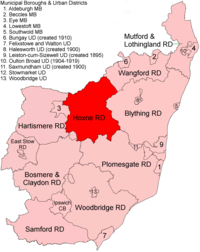 Location within East Suffolk, 1894 | |
| History | |
| • Created | 1894 |
| • Abolished | 1934 |
| • Succeeded by | Hartismere Rural District |
| Status | Rural district |
In 1934, under a County Review Order, Hoxne Rural District was abolished and its parishes transferred to Hartismere Rural District, and in 1974 to Mid Suffolk district. 3 parishes went into the new Blyth Rural District.
Statistics
| Year | Area[2] | Population [3] |
Density (pop/ha) | |
|---|---|---|---|---|
| acres | ha | |||
| 1911 | 52,842 | 21,385 | 10,408 | 0.49 |
| 1921 | 9,631 | 0.45 | ||
| 1931 | 9,045 | 0.42 | ||
Parishes
Parishes which would be transferred to Hartismere RD: Athelington, Bedfield, Bedingfield, Brundish, Denham, Fressingfield, Horham, Hoxne, Laxfield, Mendham, Metfield, Monk Soham, Southolt, Stradbroke, Syleham, Tannington, Weybread, Wilby, Wingfield, Worlingworth.
Transferred to Blyth RD: Badingham, Dennington, Saxtead
gollark: Wait, can I do `--(c++)`?
gollark: Sad!
gollark: Doesn't that evaluate to (the original value of) `c - 1`?
gollark: Wait, is it? I don't trust anything complex using inc/dec operators.
gollark: I also like to make my UIs colourful because it looks nicer and for easy identification of important sections.
References
- "Hoxne RD through time: Census tables with data for the Local Government District". A Vision of Britain through Time. GB Historical GIS / University of Portsmouth. Retrieved 9 July 2017.
- "Hoxne RD through time: Population Statistics: Area (acres)". A Vision of Britain through Time. GB Historical GIS / University of Portsmouth. Retrieved 9 July 2017.
- "Hoxne RD through time: Population Statistics: Total Population". A Vision of Britain through Time. GB Historical GIS / University of Portsmouth. Retrieved 9 July 2017.
This article is issued from Wikipedia. The text is licensed under Creative Commons - Attribution - Sharealike. Additional terms may apply for the media files.