Hopsten
Hopsten is a municipality in the district of Steinfurt, in North Rhine-Westphalia, Germany. It is situated approximately 15 km northeast of Rheine and 25 km southeast of Lingen.
Hopsten | |
|---|---|
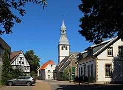 Historical center of the town | |
 Coat of arms | |
Location of Hopsten within Steinfurt district 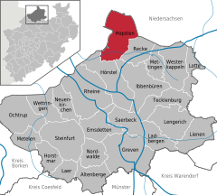  | |
 Hopsten  Hopsten | |
| Coordinates: 52°22′50″N 7°36′00″E | |
| Country | Germany |
| State | North Rhine-Westphalia |
| Admin. region | Münster |
| District | Steinfurt |
| Subdivisions | 3 |
| Government | |
| • Mayor | Winfried Pohlmann (SPD) |
| Area | |
| • Total | 99.8 km2 (38.5 sq mi) |
| Elevation | 40 m (130 ft) |
| Population (2018-12-31)[1] | |
| • Total | 7,599 |
| • Density | 76/km2 (200/sq mi) |
| Time zone | CET/CEST (UTC+1/+2) |
| Postal codes | 48496 |
| Dialling codes | 05458 |
| Vehicle registration | ST |
| Website | www.hopsten.de |
Gallery
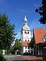 Catholic Church
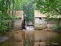 Mill Halverde
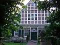 Haus Nieland
 Hof Holling on the Brennikmeyer Street
| Wikimedia Commons has media related to Hopsten. |
gollark: Not really. You already have a browser open.
gollark: Close Discord and use the browser one, delete Windows, moar RAM.
gollark: Yes, so give mineκraft half the RAM.
gollark: Allocate 4GB or else.
gollark: There are some, but they're basically entirely disused and most are *fairly* secure.
References
- "Bevölkerung der Gemeinden Nordrhein-Westfalens am 31. Dezember 2018" (in German). Landesbetrieb Information und Technik NRW. Retrieved 10 July 2019.
Towns and municipalities in Steinfurt (district) | ||
|---|---|---|
Coat of Arms of Steinfurt district | ||
| Authority control |
|
|---|
This article is issued from Wikipedia. The text is licensed under Creative Commons - Attribution - Sharealike. Additional terms may apply for the media files.