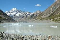
Hooker Lake
Hooker Lake is a proglacial lake that started to form in the late 1970s by the recent retreat of the Hooker Glacier. It is located in the Hooker Valley, within the Aoraki / Mount Cook National Park in New Zealand's South Island, just south of Aoraki / Mount Cook.
| Hooker Lake | |
|---|---|
 Hooker Glacier Lake in front of Aoraki / Mount Cook in summer | |
| Location | Mount Cook National Park, South Island |
| Coordinates | 43°40′45″S 170°06′30″E |
| Type | Proglacial lake |
| Primary outflows | Hooker River |
| Basin countries | New Zealand |
| Max. length | 2.5 kilometres (1.6 mi) (2016)[1] |
| Max. width | 0.5 kilometres (0.31 mi)[1] |
| Max. depth | 136 metres (446 ft)[2] |
| Surface elevation | 877 metres (2,877 ft) |
| Frozen | most winters[2] |
Etymology
The geographic Hooker items were named by the Canterbury provincial geologist, Julius von Haast, after the English botanist William Jackson Hooker.[3]
Description
Hooker Lake's length has doubled between 1990 and 2013 from 1.2 kilometres to 2.3 kilometres, retreating by over 50 metres (160 ft) per year.[4] The lake is expected to grow in length by another 4 kilometres (2.5 mi) as Hooker Glacier retreats further up the valley until the glacier's retreat will have reached the point where the glacier bed is higher than the lake's water level.[5]
Hooker Lake is one of the most accessible glacier lakes and can be reached all year round from the White Horse Hill camping ground near Mount Cook Village via the well-formed Hooker Valley Track. The walking track ends at a lookout point at the lake's shore, with a short path providing easy access to the shore.
In the warmer months icebergs can typically be seen floating in the water. The icebergs slowly drift from the terminus of Hooker Glacier at the northern end of the lake south until close to the shore. The lake's water temperature is typically lower than 2 °C (36 °F).[2]

In winter, the lake freezes over,[6] and at the coldest time of the year it can be safe to walk onto the ice.
Hooker Lake drains into Hooker River, its glacial waters coloured a blueish light grey due to the suspended glacial rock flour.
There are no boat tours on Hooker Lake, only on the larger nearby Tasman Lake.
See also
References
| Wikimedia Commons has media related to Hooker Lake. |
- "Hooker Lake, Canterbury - NZ Topo Map". NZ Topo Map. Land Information New Zealand. Retrieved 26 August 2016.
- Charles R. Warren & Martin P. Kirkbride (1998). Temperature and bathymetry of ice-contact lakes in Mount Cook National Park, New Zealand - New Zealand Journal of Geology and Geophysics. 41. Royal Society of New Zealand. pp. 133–143.
- "Hooker Valley". New Zealand Geographic. March–April 2011. Retrieved 20 April 2020.
- Clare M. Robertson (2013). Calving retreat and proglacial lake growth at Hooker Glacier, Southern Alps, New Zealand. 69. New Zealand Geographer. pp. 14–25.
- "Rapid melting of the terminal section of the Hooker Glacier". University of Auckland. Retrieved 26 August 2016.
- "Walks around Aoraki / Mount Cook village" (PDF). Department of Conservation. Retrieved 26 August 2016.