Hoogezand-Sappemeer
Hoogezand-Sappemeer (Dutch pronunciation: [ɦoːɣəˌzɑnt sɑpəˈmeːr] (![]()
Hoogezand-Sappemeer | |
|---|---|
Former municipality | |
.svg.png) Location in Groningen | |
| Coordinates: 53°9′N 6°45′E | |
| Country | Netherlands |
| Province | Groningen |
| Municipality | Midden-Groningen |
| Established | 1949 |
| Ceased to exist | 2017 |
| Area | |
| • Total | 72.99 km2 (28.18 sq mi) |
| • Land | 66.71 km2 (25.76 sq mi) |
| • Water | 6.28 km2 (2.42 sq mi) |
| Elevation | 2 m (7 ft) |
| Time zone | UTC+1 (CET) |
| • Summer (DST) | UTC+2 (CEST) |
| Postcode | 9600–9614, 9630–9633 |
| Area code | 0598 |
Geography
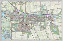
Population centres in the municipality are:
- Achterdiep
- Borgercompagnie
- Borgweg
- Foxham
- Foxhol
- Foxholsterbosch
- Hoogezand
- Jagerswijk
- Kalkwijk
- Kiel-Windeweer
- Kleinemeer
- Kropswolde
- Lula
- Martenshoek
- Meerwijck
- Nieuwe Compagnie
- Sappemeer
- Tripscompagnie
- Waterhuizen
- Westerbroek
- Wolfsbarge
Transportation
The A7 motorway (European Highway E 22, Amsterdam-Groningen-Germany) crosses the municipality. There is also a railway line providing service to Groningen and Nieuweschans/Leer(Germany). Trains serve four stations in the municipality, Kropswolde, Martenshoek, Hoogezand-Sappemeer, and Sappemeer Oost. Since 2007, trains will stop 4 times an hour.
References
- "Kerncijfers wijken en buurten" [Key figures for neighbourhoods]. CBS Statline (in Dutch). CBS. 2 July 2013. Retrieved 12 March 2014.
- "Postcodetool for 9603AE". Actueel Hoogtebestand Nederland (in Dutch). Het Waterschapshuis. Archived from the original on 21 September 2013. Retrieved 23 January 2014.
External links
- Official website

Places adjacent to Hoogezand-Sappemeer | ||||||||||
|---|---|---|---|---|---|---|---|---|---|---|
| ||||||||||