Highway 35 (Israel)
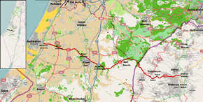
Highway 35 is a highway in south-central Israel. It runs roughly from west to east. It begins in Ashkelon, passes through the Lakhish region and Kiryat Gat, crosses the Green Line and terminates at a junction with Highway 60 near Hebron. Highway 35 is 58 km long. The road follows the "Lachish Road", an ancient east-west trade route connecting the Via Maris and the Way of the Patriarchs
| |
|---|---|
| כביש שלושים וחמש Kvish Shloshim ve'Hamesh | |
 | |
| Route information | |
| Length | 58 km (36 mi) |
| Major junctions | |
| West end | Ashkelon (Berekhya Junction) |
| |
| East end | Hebron (HaOkfim Junction) |
| Location | |
| Major cities | Ashkelon, Kiryat Gat, Beit Guvrin, Tarqumiyah, Idhna, Halhul, Hebron |
| Highway system | |
| Roads in Israel Highways | |

Junctions and interchanges on the highway
| Km | Location | Name | Type | Meaning | Intersecting routes |
|---|---|---|---|---|---|
| Highway 35 | |||||
| 0 | Ashkelon | צומת ברכיה (Berekhya Junction) |
Highway 4 | ||
| 1.9 | Berekhya, Mash'en | (Junction with Route 3500) | Road 3500 | ||
| 3.4 | Ganei HaTzvi Events Center | entrance road | |||
| 5.8 | Sde Yoav | צומת גבעתי (Givati Junction) |
Route 232 North | ||
| 6 | Sde Yoav | צומת גבעתי (Givati Junction) |
Route 232 South | ||
| 7.7 | Sde Yoav, Negba, Yoav Fort |
מחלף נגבה (Negba Interchange) |
entrance road | ||
| 8.6 | Hamei Yoav (Yoav Spa) | entrance road | |||
| 9.6 | Otzem | צומת נהורה (Nehora Junction) |
Route 352 | ||
| 10.3 | Yad Natan | צומת ליד נתן (Yad Natan Junction) |
HaMiyasdim St | ||
| 13 | Revaha | צומת רווחה (Revaha Junction) |
Road 3533 | ||
| 15.2 | Camp Plugot | entrance road | |||
| 15.4 | Netiv HaLamed Hei Reservoir | (eastbound only) | entrance road | ||
| 16.5 | Kiryat Gat | צומת פלוגות (Plugot Junction) |
Highway 40 | ||
| 17.8 | Kiryat Gat | מחלף קרית גת צפון (Kiryat Gat North Interchange) |
Lakhish Boulevard | ||
| 17.9 | HaZera Genetics Mivhor Seed Farm | Eliminated 2016</small | entrance road | ||
| 19 | Kiryat Gat | מחלף קריית גת מזרח (Qiryat Gat South Interchange) |
(westbound only) | Road 3444 HaDarom Road | |
| 19.2 | Kiryat Gat | מחלף קריית גת מזרח (Qiryat Gat South Interchange) |
(eastbound only) | Road 3444 HaDarom Road | |
| 20.1 | Kiryat Gat Industrial Zone | Israel Polack Blvd. | |||
| 21 | Kiryat Gat Industrial Zone | (eastbound only) | local road | ||
| 22.1 | Sde Moshe | צומת כניסה לשדה משה (Sde Moshe Junction) |
Kerem St | ||
| 22.9 | Kiryat Gat | מחלף קריית גת (Qiryat Gat Interchange) |
Highway 6 | ||
| 24.4 | Melakhim Forest (Shaharriya Park) |
צומת שחריה (Shaharriya Junction) |
entrance road | ||
| 25.5 | Lakhish Reservoir | entrance road | |||
| 26.1 | Lakhish, Tel Lakhish | צומת לכיש (Lachish Junction) |
Road 3415 | ||
| 31.9 | Magav Camp (South) | entrance road | |||
| 32.5 | Beit Guvrin rest stop | צומת גוברין (Guvrin Junction) |
House of the Powerful | local road to Beit Nir | |
| 32.6 | Beit Guvrin National Park | entrance road | |||
| 32.9 | Beit Guvrin | צומת כניסה לבית גוברין (Beit Guvrin Entrance) |
entrance road | ||
| 33.7 | Beit Guvrin | צומת נחושה (Nehusha Junction) |
Steadfast | Highway 38 | |
| 36 | Kfar Zoharim | צומת כניסה לכפר זוהרים | entrance road | ||
| 38.3 | Nehusha, Green Line | צומת כביש 358 (Route 358 Junction, planned as of 2007) |
Route 358 | ||
| 40.2 | Green Line | ||||
| 41.3 | Green Line, Tarqumiya Terminal[1][2] |
entrance to passenger terminal and cargo transfer station | |||
| 41.5 | Tarqumiyah Security Checkpoint | ||||
| 41.7 | Tarqumiyah Terminal | entrance to passenger terminal and cargo transfer station | |||
| 42.9 | Tarqumiyah | Road 3556 yellow (Israeli) license plates | |||
| 44.5 | Tarqumiyah | צומת כביש 354 | Route 354 North yellow (Israeli) license plates | ||
| 44.6 | Idhna | צומת כביש 354 | Route 354 South yellow (Israeli) license plates | ||
| 48.6 | Adora | צומת לאדורה (Adora Junction) |
ult. House named after Adurim |
entrance road | |
| 49.9 | Telem | צומת לתלם (Telem Junction) |
entrance road | ||
| 51.2 | factory | entrance road | |||
| 51.8 | Camp Telem | entrance road | |||
| 53.8 | Hebron (West), Beit Kahil |
Local road yellow (Israeli) license plates | |||
| 56.3 | Hebron, Halhul |
צומת הזכוכית (HaZchuhit Junction) |
Glass | Local road yellow (Israeli) license plates | |
| 57.9 | Hebron, Halhul |
צומת העוקפים (HaOkfim Junction) |
Bypasses | Highway 60 | |
gollark: There are lots of legal things involved and you need an amateur license.
gollark: cloud blockchain with artificial intelligence aspects
gollark: 🌵🌵🌵
gollark: I actually assumed you meant the Dell tower server.
gollark: I think that apart from RAM the new osmarks.tk™ server may actually be better.
References
- "Crossing Points West Bank and Gaza Strip - Tarqumiya Terminal". Palestinian Shipper's Council. Archived from the original on 2014-08-26. Retrieved 2014-08-22.
- "Coordination of Government Activity in the Territories - Tarqumiyah Crossing". Israel Defense Forces. Archived from the original on 2014-08-26. Retrieved 2014-08-22.
See also
- List of highways in Israel
| Roads |
| ||||
|---|---|---|---|---|---|
| Bus operators | |||||
| Rail transport |
| ||||
| Sea ports | |||||
| Aviation |
| ||||
| Cable cars | |||||
| By city | |||||
| Smart cards | |||||
This article is issued from Wikipedia. The text is licensed under Creative Commons - Attribution - Sharealike. Additional terms may apply for the media files.