Herrngiersdorf
Herrngiersdorf is a municipality in the district of Kelheim in Bavaria in Germany. The village is dominated by the large, square Schloss Herrngiersdorf, a brewery.
Herrngiersdorf | |
|---|---|
 Coat of arms | |
Location of Herrngiersdorf within Kelheim district 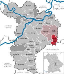 | |
 Herrngiersdorf  Herrngiersdorf | |
| Coordinates: 48°48′N 12°4′E | |
| Country | Germany |
| State | Bavaria |
| Admin. region | Niederbayern |
| District | Kelheim |
| Municipal assoc. | Langquaid |
| Area | |
| • Total | 25.09 km2 (9.69 sq mi) |
| Elevation | 405 m (1,329 ft) |
| Population (2018-12-31)[1] | |
| • Total | 1,295 |
| • Density | 52/km2 (130/sq mi) |
| Time zone | CET/CEST (UTC+1/+2) |
| Postal codes | 84097 |
| Dialling codes | 09452 |
| Vehicle registration | KEH |
| Website | www.herrngiersdorf.de |
Geography
Herrngiersdorf is located south of Langquaid and consists of Herrngiersdorf, Sandsbach, Semerskirchen, and Sittelsdorf.
Gallery
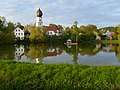 Lake at Semerskirchen
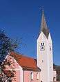 St. Martin's church
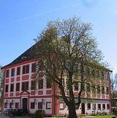
gollark: <:dodecahedron:724893894822854697>
gollark: <:dodecahedron:724893894822854697>.tk
gollark: Heavpoot only has ☭☭☭☭.tk, which is one less ☭.
gollark: I own that domain. Well, "own".
gollark: Hey, I could run osmarkstube™ on ☭☭☭☭☭.tk!
References
- "Fortschreibung des Bevölkerungsstandes". Bayerisches Landesamt für Statistik und Datenverarbeitung (in German). July 2019.
External links
| Wikimedia Commons has media related to Herrngiersdorf. |
| Wikivoyage has a travel guide for Herrngiersdorf. |
Towns and municipalities in Kelheim (district) | ||
|---|---|---|
Coat of Arms of Kelheim district | ||
This article is issued from Wikipedia. The text is licensed under Creative Commons - Attribution - Sharealike. Additional terms may apply for the media files.