Heinrich-Heine-Straße (Berlin U-Bahn)
Heinrich-Heine-Straße is a Berlin U-Bahn station on the ![]()
History
After the City of Berlin took over the incomplete GN-Bahn (Gesundbrunnen - Neukölln Railway) line from the AEG subsidiary which was unable to complete it in the aftermath of World War I, the Neanderstraße station was built in 1926–28 and opened on 6 April 1928.[1] It was the northern terminus of the line for two years, until 18 April 1930, when Gesundbrunnen station opened.[2]
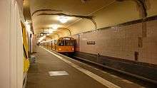
Alfred Grenander designed the station in his characteristic sparse New Objectivist style and chose pale violet or aubergine (similar to Kottbusser Tor[1]) as the distinguishing colour for the wall tiles and the tiled central pillars on the platform level.[3]
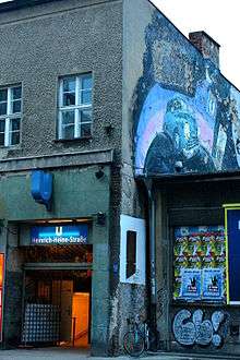
The station lies at "one and a half depth" because it is under buildings. Like many Berlin U-Bahn stations, it has an island platform and entrances at both ends, north and south. All are stairways; the station has no lift.[4] One of the two northern entrances is incorporated into a building on the corner of Köpenicker Straße, with offices and flats above. This building is also protected as an architectural landmark.[3] The other northern entrance and the southern entrance, at the corner of Schmidstraße, were also formerly incorporated into buildings, one of the models being entrances to London Underground stations; Neanderstraße was then unusually narrow and this line was the first use in Berlin of entrances set into buildings.[5][6] The other buildings were destroyed in World War II and those stairs have since led directly from the street.[3]
Following the fall of Berlin, the U-Bahn was closed at the end of April 1945. Service resumed at Neanderstraße on 3 June that year.[7] Mitte was within the Soviet zone which became East Berlin; the station was renamed Heinrich-Heine-Straße on 31 August 1960 following a decision by the Berlin Magistrat on 22 July to rename the street. After the construction of the Berlin wall a year later, on 13 August 1961, U-Bahn trains on Lines C and D (![]()
![]()
The Sage Club, a Berlin dance club, has operated since 1997 in the disused station mezzanine level in the Köpenicker Straße building.[9][10]
References
- Die GN-Bahn: Südlicher Abschnitt Archived 2011-05-25 at the Wayback Machine, Berliner-Untergrundbahn.de (in German)
- Sabine Bohle-Heintzenberg, Architektur der Berliner Hoch- und Untergrundbahn: Planungen, Entwürfe, Bauten bis 1930, Berlin: Ahrenhövel, 1980, ISBN 978-3-922912-00-2, p. 186 (in German)
- U-Bahnhof Heinrich-Heine-Straße, OBJ-Dok-Nr. 09035374, Denkmale in Berlin, Senatsverwaltung für Stadtentwicklung, Berlin, updated 25 March 2008, retrieved 22 February 2011 (in German)
- See the map of the station's location, Berliner Verkehrsbetriebe (pdf)
- Bohle-Heintzenberg, p. 188 (in German)
- Petra Domke and Markus Hoeft, Tunnel, Gräben, Viadukte: 100 Jahre Baugeschichte der Berliner U-Bahn, Berlin: Kulturbild, 1998, ISBN 978-3-933300-00-3, p. 102 (in German)
- Kriegsende in Berlin Archived 2011-07-18 at the Wayback Machine, Berliner-untergrundbahn.de (in German)
- Bahnhof Heinrich-Heine-Straße, Michael König, Stadtregion.org (in German)
- Sarah Curth, Sage Club – Rock in Berlin – Rock at Sage Archived 2011-01-25 at the Wayback Machine, Spottedbylocals.com, updated 21 February 2011, retrieved 23 February 2011: "located inside the U-Bahnhof Heinrich-Heine-Straße"
- Sage Club review Archived 2011-01-29 at the Wayback Machine, TimeOut Berlin, retrieved 23 February 2011: "A labyrinthine complex of half a dozen or so dancefloors accessed via the north-side entrance to Heinrich-Heine-Strasse U-Bahn station"
External links
| Wikimedia Commons has media related to U-Bahnhof Heinrich-Heine-Straße. |
- Gallery at Untergrundbahn.de
- Club description page at Sage Club (in German)
| Preceding station | Berlin U-Bahn | Following station | ||
|---|---|---|---|---|
Jannowitzbrücke towards Wittenau | towards Hermannstraße |