Hazara District
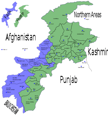
Hazara District was district of Peshawar Division in the North-West Frontier Province of Pakistan until 1976.

The Imperial Gazetteer of India described the district as follows.
Northernmost District of the North - West Frontier Province, and the only portion of that Province east of the Indus. It lies between 33° 44′ and 35° 10′ N. and 72° 33′ and 74° 6′ E., with an area Of 2,858, or, including Tanāwal, 3,062 square miles (7,930 km2). The District consists of a long tongue of British territory running north and south for 120 miles (190 km). The southern base is 56 miles (90 km) in width, and the centre 40, while the Kāgān valley, in the north east, is only about 15 miles (24 km) broad. On the north the Kāgān range separates the District from Chilās, a dependency of Kashmir; and on the east the range which borders the left bank of the Kunhār river and the Jhelum separates it from Kashmir, Punch, and the Punjab, District of Rawalpindi ; north-west lie the Black Mountain and the lofty ranges which overhang the eastern bank of the Indus; and on the south is Attock District of the Punjab. Thus the District lies like a wedge of British territory driven in between Kashmir on the east and the independent hills on the west. Hazara presents every gradation of scenery, altitude, and climate. The valley of the Harroh, only 1,500 feet (460 m) above sea-level, merges into the Hazara plain, an area of 200 square miles (520 km2), with a mean elevation of 2,500 feet (760 m). Higher again is the Orāsh plain, where Abbottābād lies between 4,000 and 5,000 feet (1,500 m) above the sea. Lastly the Kāgān valley, comprising one-third of the total area, is a sparsely populated mountain glen, shut in by parallel ranges of hills which rise to 17,000 feet (5,200 m) above the sea. Never more than 15 miles (24 km) apart, these ranges throw out spurs across the valley, leaving only a narrow central gorge through which the Kunhar river forces an outlet to the Jhelum[1]
.
Current status
The Hazara District is now divided into Abbottabad, Mansehra and Haripur districts.