Harrys Brook
Harrys Brook, also known as the H. Greenlands Brook,[1] is a tributary of the Millstone River in Mercer County, New Jersey in the United States.
| Harrys Brook | |
|---|---|
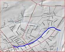 Map of Harrys Brook | |
| Location | |
| Country | United States |
| Physical characteristics | |
| Source | |
| • coordinates | 40°21′32″N 74°38′54″W |
| Mouth | |
• coordinates | 40°21′57″N 74°37′40″W |
• elevation | 52 ft (16 m) |
| Basin features | |
| Progression | Millstone River, Raritan River, Atlantic Ocean |
| River system | Raritan River system |
Course
Harrys Brook starts at 40°21′32″N 74°38′54″W,[1] near Princeton North. It flows northeast though the city before meeting with another tributary from the northwest. It crosses Route 27 and drains into the Millstone River at 40°21′57″N 74°37′40″W.[1]
Sister tributaries
- Beden Brook
- Bear Brook
- Cranbury Brook
- Devils Brook
- Heathcote Brook
- Indian Run Brook
- Little Bear Brook
- Millstone Brook
- Peace Brook
- Rocky Brook
- Royce Brook
- Simonson Brook
- Six Mile Run
- Stony Brook
- Ten Mile Run
- Van Horn Brook
gollark: ++magic reload_ext esoserver
gollark: <@!160279332454006795> <@&832006325491335168> test
gollark: Oh dear, it crashed.
gollark: <@!160279332454006795> <@&832006325491335168> test
gollark: I IKR, right?
See also
References
- "GNIS Detail - Harrys Brook". USGS. Retrieved 22 July 2010.
This article is issued from Wikipedia. The text is licensed under Creative Commons - Attribution - Sharealike. Additional terms may apply for the media files.