Devils Brook
Devils Brook is a tributary of the Millstone River in central New Jersey in the United States.
| Devils Brook | |
|---|---|
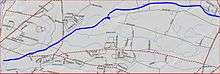 Devils Brook map | |
| Location | |
| Country | United States |
| Physical characteristics | |
| Source | |
| • coordinates | 40°21′22″N 74°29′47″W |
| Mouth | |
• coordinates | 40°19′49″N 74°37′27″W |
• elevation | 59 ft (18 m) |
| Basin features | |
| Progression | Millstone River, Raritan River, Atlantic Ocean |
| River system | Raritan River system |
| Tributaries | |
| • left | Shallow Brook |
It is a moderately large brook with numerous unnamed tributaries.
Course
The Devils Brook starts at 40°21′22″N 74°29′47″W,[1] near exit 8A on the New Jersey Turnpike. It flows west, following Friendship Road. It then passes through the Plainsboro Preserve, feeding a marsh. It joins with Shallow Brook, its tributary, and crosses Scudders Mill Road, also known as CR-614. It crosses Princeton-Plainsboro Road in a dammed section known as Gordon Pond. It then drains into the Millstone River at 40°19′49″N 74°37′27″W.[1]
Accessibility
The Devils Brook drains a large area in Mercer and Middlesex counties. There are many tributaries that cross roads, so it is easily accessible.
Tributaries
Sister tributaries
- Beden Brook
- Bear Brook
- Cranbury Brook
- Harrys Brook
- Heathcote Brook
- Indian Run Brook
- Little Bear Brook
- Millstone Brook
- Peace Brook
- Rocky Brook
- Royce Brook
- Simonson Brook
- Six Mile Run
- Stony Brook
- Ten Mile Run
- Van Horn Brook
gollark: First purchasers put it up 100 shards.
gollark: It's self-correcting, I just realised, ish.
gollark: If it does, it'll probably be fixed within a few weeks.
gollark: Which is probably a significant improvement for anyone but sunfish or, well, prize owners.
gollark: Yes, in about... eight months now?
See also
References
- "GNIS Detail - Devils Brook". USGS. Retrieved 6 July 2010.
External links
This article is issued from Wikipedia. The text is licensed under Creative Commons - Attribution - Sharealike. Additional terms may apply for the media files.