Harinas
Harinas (Nepali: हरिनास) is a Village council in Syangja District in Gandaki Pradesh, central Nepal.
Harinas हरिनास | |
|---|---|
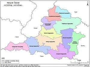 Harinas village council in the map of Syangja Districtl | |
 Harinas Location in Nepal | |
| Coordinates: 28°0′N 83°59′E | |
| Country | |
| Nepalese Federal States | Gandaki Pradesh |
| District | Syangja District |
| Area | |
| • Total | 87.48 km2 (33.78 sq mi) |
| Population | |
| • Total | 17,343 |
| • Density | 200/km2 (510/sq mi) |
| Time zone | UTC+5:45 (Nepal Time) |
| Website | http://harinasmun.gov.np/ |
History
In 12 March 2017, the government of Nepal implemented a new local administrative structure consisting of 744 local units.[1][2] With the implementation of the new local administrative structure, VDCs have been replaced with municipal & village councils.[3] Harinas is one of these 744 local units.[4] Harinas is created by merging Magyam Chisapani, Chitre Bhanjyang, (7-9) wards of Chinnebas, Kyakami & (6,8,9) wards of Kichnas.[5]
Political situation
Harinas is divided into 7 Wards. It is surrounded by Tanahun District at northern side, Tanahun District from east, Chapakot & Biruwa from west and Chapakot & Tanahun District at south. Chitre Bhanjyang is its headquarter.[4]
Population
As Harinas is created by merging Magyam Chisapani, Chitre Bhanjyang, (7-9) wards of Chinnebas, Kyakami & (6,8,9) wards of Kichnas. The sum population of Harinas, 17,343, is residing in an area of 87.48 km2.[6]
References
- "PM Dahal inaugurates operation of 744 local levels". The Himalayan Times. Retrieved 14 March 2017.
- "744 new local units come into effect". The Kathmandu Post. Retrieved 15 March 2017.
- "New civic set-up comes into effect". The Himalayan Times. Retrieved 11 March 2017.
- "Which local units are you in?". Seto Pati. Archived from the original on 12 March 2017. Retrieved 16 March 2017.
- "Which local unit do you belong to?". MyRepublica. Retrieved 11 March 2017.
- "Syangja VDC Level Report" (PDF). Central Bureau of Statistics. Archived from the original (PDF) on 2014-10-26.