Hardthausen am Kocher
Hardthausen am Kocher is a town in the district of Heilbronn in Baden-Württemberg in southern Germany.
Hardthausen am Kocher | |
|---|---|
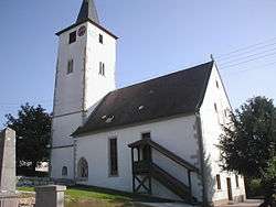 Church in Lampoldshausen | |
 Coat of arms | |
Location of Hardthausen am Kocher within Heilbronn district 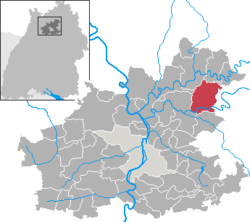 | |
 Hardthausen am Kocher  Hardthausen am Kocher | |
| Coordinates: 49°14′N 9°24′E | |
| Country | Germany |
| State | Baden-Württemberg |
| Admin. region | Stuttgart |
| District | Heilbronn |
| Subdivisions | 3 |
| Government | |
| • Mayor | Thomas Einfalt |
| Area | |
| • Total | 35.55 km2 (13.73 sq mi) |
| Elevation | 182 m (597 ft) |
| Population (2018-12-31)[1] | |
| • Total | 4,159 |
| • Density | 120/km2 (300/sq mi) |
| Time zone | CET/CEST (UTC+1/+2) |
| Postal codes | 74239 |
| Dialling codes | 07139 |
| Vehicle registration | HN |
| Website | www.hardthausen.de |
Geography
Location
Hardthausen lies in the east of the county of Heilbronn in the lower Kocher valley on the southern edge of the Harthausen Forest.
gollark: I'm limited by whatever random files the openzim people provide, unless I expend great* effort running the wiki archiver script myself.
gollark: I have Wikipedia, ArchWiki, several stackexchange sites (not technically *wikis*), the CC wikis (old/new), Wikivoyage, the Gentoo wiki, "All The Tropes", and actually that's it.
gollark: Of course.
gollark: I should download this to the osmarks.tk wiki archive™.
gollark: Wait, what's "wiki encyclopedia"?
References
- "Bevölkerung nach Nationalität und Geschlecht am 31. Dezember 2018". Statistisches Landesamt Baden-Württemberg (in German). July 2019.
| Wikimedia Commons has media related to Hardthausen am Kocher. |
| Authority control |
|
|---|
This article is issued from Wikipedia. The text is licensed under Creative Commons - Attribution - Sharealike. Additional terms may apply for the media files.