Hardt, Baden-Württemberg
Hardt is a municipality in the district of Rottweil, in Baden-Württemberg, Germany.
Hardt | |
|---|---|
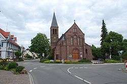 St. George's Church, Hardt | |
 Coat of arms | |
Location of Hardt within Rottweil district 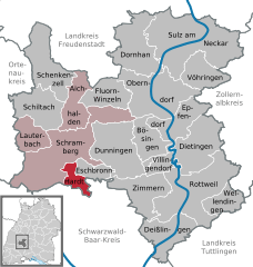  | |
 Hardt  Hardt | |
| Coordinates: 48°11′02″N 08°24′41″E | |
| Country | Germany |
| State | Baden-Württemberg |
| Admin. region | Freiburg |
| District | Rottweil |
| Area | |
| • Total | 10.17 km2 (3.93 sq mi) |
| Elevation | 785 m (2,575 ft) |
| Population (2018-12-31)[1] | |
| • Total | 2,532 |
| • Density | 250/km2 (640/sq mi) |
| Time zone | CET/CEST (UTC+1/+2) |
| Postal codes | 78739 |
| Dialling codes | 07422 |
| Vehicle registration | RW |
| Website | www |
History
Hardt was first mentioned in 1416 as "Hard", a property in the township of Mariazell and of the House of Falkenstein,[2] who governed from Schramberg. Schramberg was dissolved by the process of German mediatization in 1806 and its territories were awarded to the Kingdom of Württemberg. Hardt was assigned to Oberamt Hornberg, which was dissolved on 2 October 1810 by a border treaty with the Grand Duchy of Baden. Hardt was subsequently assigned to a new Oberamt, Oberamt Oderndorf. In 1839, Hardt became an independent municipality. The district of Oberndorf was dissolved on 1 October 1938, and Hardt returned to the jurisdiction of Rottweil.[3]
Geography
The municipality (Gemeinde) of Hardt covers 10.17 square kilometers (3.93 sq mi) of the district of Rottweil, in the German state of Baden-Württemberg. Hardt is physically located in the Central Black Forest. Elevation above sea level in the municipal area ranges from a high of 834 meters (2,736 ft) Normalnull (NN) at the Hochwald to a low of 597 meters (1,959 ft) NN on the Kirnbach at the border with Schramberg.[3]
Coat of arms
Hardt's coat of arms depicts, in green, a field with two fir trees upon a field of white. Between the trees is a smaller blazon with a stag upon a trimount, both in yellow, upon a field of blue. This pattern was devised in 1953 from a Schultheiß's seal that featured the firs, but was distinguished from similar coats of arms by the addition of the arms of the House of Falkenstein. The arms of the 17th century Falkenstein zu Rimsingen line are erroneously used on Hardt's coat of arms.[3]
References
- "Bevölkerung nach Nationalität und Geschlecht am 31. Dezember 2018". Statistisches Landesamt Baden-Württemberg (in German). July 2019.
- "Hardt - Altgemeinde". LEO-BW (in German). Baden-Württemberg. Retrieved 24 July 2020.
- "Hardt". LEO-BW (in German). Baden-Württemberg. Retrieved 24 July 2020.
External links
- Official website

Towns and municipalities in Rottweil (district) | ||
|---|---|---|
| Authority control |
|
|---|