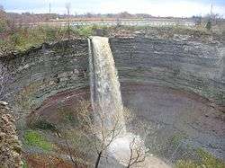
Hamilton ravine system
The Hamilton ravine system is one of the most distinctive features of the geography of Hamilton, Ontario, Canada. It is a network of deep ravines that form a large urban forest that runs throughout much of the city. For the most part designated as parkland, the ravines are somewhat undeveloped.

Origin
Hamilton is known for having the Niagara Escarpment run through the entire city. This was formed after the end of the last Ice Age some 12,000 years ago by glacier movements that carved the area of which the Great Lakes are now situated.[1] Many of the streams located on the top of the escarpment that would drain into the higher-elevated lakes would eventually form most of Hamilton's waterfalls and cascades after the lake levels receded. Eventually these streams eroded the soft sand-like soils in the lower section of Hamilton area, and form many of their ravines today
Human use
Despite the moderately dense population of metropolitan Hamilton, many of the ravines have been left close to their natural state. The most important reason for this is the danger of slight flooding. The rivers and streams that flow through the ravines are highly variable. During the late summer, many of the smaller ones will slow to a trickle. During the spring and after major storms, the creeks often overflow their banks and flood the marshy lands that surround most of them. Many of these ravines located on the Stoney Creek, Ontario section of Hamilton have small human intervention tunnels in them allowing the water to flow through so a road can exist above. Other human intervention includes parks, trails, nearby houses, and even small factories or warehouses nearby although they are not used to extract water or dump their wastes.
References
- Escarpment.org. "The Natural History of the Niagara Escarpment" (PDF). Archived from the original (PDF) on 4 March 2016. Retrieved 14 June 2015.