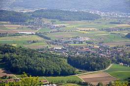
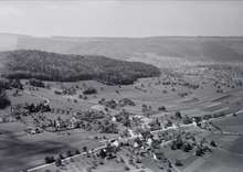
Hüttikon
Hüttikon is a municipality in the district of Dielsdorf in the canton of Zürich in Switzerland.
Hüttikon | |
|---|---|
 | |
 Coat of arms | |
Location of Hüttikon 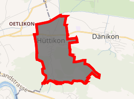
| |
 Hüttikon Hüttikon | |
| Coordinates: 47°27′N 8°23′E | |
| Country | Switzerland |
| Canton | Zurich |
| District | Dielsdorf |
| Area | |
| • Total | 1.62 km2 (0.63 sq mi) |
| Elevation | 433 m (1,421 ft) |
| Population (2018-12-31)[2] | |
| • Total | 925 |
| • Density | 570/km2 (1,500/sq mi) |
| Postal code | 8115 |
| SFOS number | 0087 |
| Surrounded by | Dänikon, Oetwil an der Limmat, Otelfingen, Würenlos (AG) |
| Website | www SFSO statistics |
Geography
Hüttikon has an area of 1.6 km2 (0.62 sq mi). Of this area, 52.2% is used for agricultural purposes, while 36% is forested. The rest of the land, (11.8%) is settled.[4]
The municipality is located in the Furttal on the border with the Canton of Aargau. It includes the village of Hüttikon and the hamlet of Hüttikerberg.
Demographics
Hüttikon has a population (as of 31 December 2018) of 926.[5] As of 2007, 18.8% of the population was made up of foreign nationals. Over the last 10 years the population has grown at a rate of 24.4%. Most of the population (as of 2000) speaks German (89.3%), with Portuguese being second most common ( 4.5%) and Italian being third ( 0.8%).
In the 2007 election the most popular party was the SVP which received 63.4% of the vote. The next three most popular parties were the SPS (10.6%), the FDP (8.3%) and the CSP (7.1%).
The age distribution of the population (as of 2000) is children and teenagers (0–19 years old) make up 23.3% of the population, while adults (20–64 years old) make up 66.4% and seniors (over 64 years old) make up 10.3%. The entire Swiss population is generally well educated. In Hüttikon about 76.6% of the population (between age 25-64) have completed either non-mandatory upper secondary education or additional higher education (either university or a Fachhochschule).
Hüttikon has an unemployment rate of 1.42%. As of 2005, there were 33 people employed in the primary economic sector and about 11 businesses involved in this sector. 270 people are employed in the secondary sector and there are 10 businesses in this sector. 45 people are employed in the tertiary sector, with 14 businesses in this sector.[4]
The historical population is given in the following table:[3]
| year | population |
|---|---|
| 1634 | 71 |
| 1836 | 167 |
| 1850 | 178 |
| 1900 | 120 |
| 1950 | 154 |
| 1970 | 256 |
| 2000 | 533 |
References
- "Arealstatistik Standard - Gemeinden nach 4 Hauptbereichen". Federal Statistical Office. Retrieved 13 January 2019.
- https://statistik.zh.ch/internet/justiz_inneres/statistik/de/daten/gemeindeportraet_kanton_zuerich.html?tab=indikatoren&jahr=2017&indikatoren=133&bfs=87.
- Hüttikon in German, French and Italian in the online Historical Dictionary of Switzerland.
- Swiss Federal Statistical Office Archived 2016-01-05 at the Wayback Machine accessed 03-Aug-2009
- Swiss Federal Statistical Office - STAT-TAB, online database – Ständige und nichtständige Wohnbevölkerung nach institutionellen Gliederungen, Geburtsort und Staatsangehörigkeit (in German) accessed 23 September 2019
External links
| Wikimedia Commons has media related to Hüttikon. |
- Official website (in German)
Municipalities in Dielsdorf District, Switzerland | ||
|---|---|---|