Gyokutō, Kumamoto
Gyokutō (玉東町, Gyokutō-machi) is a town located in Tamana District, Kumamoto Prefecture, Japan.
Gyokutō 玉東町 | |
|---|---|
Town | |
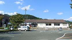 Gyokuto Town Office | |
 Flag  Chapter | |
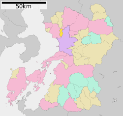 Location of Gyokutō in Kumamoto Prefecture | |
 Gyokutō Location in Japan | |
| Coordinates: 32°54′N 130°37′E | |
| Country | Japan |
| Region | Kyushu |
| Prefecture | Kumamoto Prefecture |
| District | Tamana |
| Area | |
| • Total | 24.40 km2 (9.42 sq mi) |
| Population (March 31, 2017) | |
| • Total | 5,363 |
| • Density | 220/km2 (570/sq mi) |
| Time zone | UTC+9 (JST) |
| Website | www |
As of March 2017, the town has an estimated population of 5,363[1] and the density of 220 persons per km². The total area is 24.40 km².
References
- "Official website of Gyokutō Town" (in Japanese). Japan: Gyokutō Town. Retrieved 1 May 2017.
External links

- Gyokutō official website (in Japanese)
| Authority control |
|
|---|
This article is issued from Wikipedia. The text is licensed under Creative Commons - Attribution - Sharealike. Additional terms may apply for the media files.