Gwna Group
The Gwna Group is a late Precambrian (Ediacaran) / Cambrian lithostratigraphic group (a sequence of rock strata) in northwest Wales. The name is derived from the Afon Gwna, a river near Bodorgan on Anglesey where the strata are exposed.[1] This rock sequence is also commonly referred to as the Gwna Mélange.
| Gwna Group Stratigraphic range: Ediacaran / cambrian | |
|---|---|
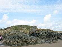 Pillow lavas at Gwddw Llanddwyn, Anglesey | |
| Type | Group |
| Unit of | Monian Supergroup |
| Underlies | Fydlyn Group |
| Overlies | Church Bay Tuffs |
| Thickness | several hundred metres |
| Lithology | |
| Primary | mélange |
| Other | schist, granite, limestone, sandstone, mudstone |
| Location | |
| Region | north Wales |
| Country | Wales |
| Type section | |
| Named for | Afon Gwna |
Outcrops
These rocks are exposed across various parts of Anglesey and along the northern coast of Llŷn and at Bardsey Island.[2][3] The extensive coastal cliffs at each of these locations affords excellent exposure.
Lithology and stratigraphy
The Group is considered to represent the result of an olistostrome, a giant underwater gravity slide, which occurred probably as a result of tectonic activity at some time after 614 million years ago. It includes clasts, at all sizes from millimetres up to a kilometre or more, of a diverse range of both sedimentary and igneous rocks. Since deposition the group as a whole has been subject to low grade metamorphism.[4]
References
- http://www.bgs.ac.uk/Lexicon/lexicon.cfm?pub=NGW (BGS on-line lexicon of rock units)
- British Geological Survey 1:50,000 scale geological map (England & Wales) sheet 133, 134 & Special sheet Anglesey
- http://mapapps.bgs.ac.uk/geologyofbritain/home.html
- Howells, M.F. 2007 British Regional Geology: Wales (Keyworth, Notts, British Geological Survey)