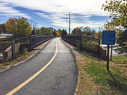
Grant's Trail
Grant's Trail is a biking and walking trail in St. Louis County, Missouri that begins at Orlando Gardens near Union Ave and I-55 and runs northwest to Holmes Ave and I-44 in Kirkwood. The trail is 8.25 miles (13.28 km) and is part of the Gravois Greenway. It connects the Meramec River Greenway to the River des Peres Greenway.[1]
| Grant's Trail | |
|---|---|
 Grant's Trail at the Kirkwood Trailhead, 2017 | |
| Length | 8.25 miles (13.28 km) |
| Location | St. Louis County, Missouri |
| Use | Walking, Biking, Running |
| Hiking details | |
| Sights | Ulysses S. Grant National Historic Site Grant's Farm |
| Surface | asphalt |
| Website | http://www.greatriversgreenway.org/trails/grants-trail.aspx |
Location
- Kirkwood (western) trailhead: 38°34′20″N 90°23′30″W[2]
- St. Louis (eastern) trailhead: 38°32′31″N 90°17′54″W[3]
gollark: https://github.com/Mashpoe/c-vector/blob/master/vec.h
gollark: This actually seems fairly reasonable, hm.
gollark: I will investigate this ""vector library"" I found on github.
gollark: That seems like a bad hack around weak types which could be prone to badness.
gollark: How do you encode in the type system "this is a vector of bees"?
See also
External links
References
- "Grant's Trail on the Gravois Greenway". Great Rivers Greenway. Archived from the original on 1 March 2015. Retrieved 7 Dec 2014.
- "Grant's Trail: Highway 44 Bridge". BikeGrantsTrail.com. Retrieved 2014-01-20.
- "Grant's Trail: Parking at Orlando's". BikeGrantsTrail.com. Retrieved 2014-01-20.
This article is issued from Wikipedia. The text is licensed under Creative Commons - Attribution - Sharealike. Additional terms may apply for the media files.