The Great Rivers Greenway District
The Great Rivers Greenway District is an organization created in November 2000 by the passage of Proposition C (The Clean Water, Safe Parks and Community Trails Initiative, or Prop C) in the City of St. Louis, St. Louis County and St. Charles County, Missouri. Prop C created a one tenth of one cent sales tax devoted to the creation of an interconnected system of greenways, parks and trails. The Great Rivers Greenway District does not have oversight over existing parks and recreation areas, but rather works to develop linear connections to connect to existing or planned parks.[1]

Governance
A twelve-member Board of Directors representing the three areas governs the distribution of funds for developing the River Ring, the system of interconnected greenways, parks and trails. An Executive Director and staff carry out the development of the River Ring, working with local, county and state agencies as well as private and non-profit agencies throughout the St. Louis region.
Plans
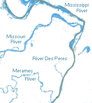
In 2003, the Great Rivers Greenway District developed "Building the River Ring: A Citizen- Driven Regional Plan" to establish a long-term vision for the St. Louis region. Working with citizens, local governments, private companies, non-profit organizations and advocacy groups, the Plan identified a system of 40+ greenways comprising over 600 miles of greenways and trails throughout the three counties. Named the River Ring, the concept is designed to raise awareness of the natural beauty found in the region's many rivers and streams and to reconnect residents to the primary natural feature resulting in the City's founding, the Mississippi and Missouri rivers.
It is the name applied to a linked system of smaller greenway projects encircling St. Louis City, St. Louis County, and St. Charles County. Each of these green belts will follow the natural paths of rivers and streams in the area.
The total project will eventually comprise more than 600 miles of trails and include more than 45 different greenways connecting existing parks, trails and greenways in the City of St. Louis, St. Louis and St. Charles Counties in Missouri with those developed by the Metro East Parks District of St. Clair and Madison Counties in Illinois.
Greenways
Greenways within the district:[2]
- Boschert Greenway
- Busch Greenway
- Centennial Greenway
- Chouteau Greenway
- Confluence Greenway
- Dardenne Greenway
- Gravois Creek Greenway
- Maline Greenway
- Meramec Greenway
- Mississippi River Greenway
- Missouri River Greenway
- River des Peres Greenway
- Shady and Deer Creek Greenways
- St. Vincent Greenway
- Sunset Greenway
- Western Greenway
Trails
Trails within the district:[3]
- Al Foster Memorial Trail
- BaratHaven Trail
- Boschert Trail
- Branch Street Trestle
- Centennial Shaw Park to Olive
- Cliff Cave Park Trail
- Clydesdale Park Connector
- Columbia Bottom Trail
- Confluence Point Trail
- Cottleville Trail
- Dardenne Greenway at Bluebird Meadow
- Deer Creek Park and Trail
- Earth City Levee Trail
- Flat Creek Trail
- George Winter to Unger County Park
- Grant's Trail
- Greentree Park to Arnold's Grove Park
- Hamilton Carr Trail
- Jefferson Barracks to River City Trail
- Katy Trail to Heritage Museum
- Lower Meramec County Park Trail
- McKelvey Woods Trail
- McKinley Bridge Bikeway and Branch Street Trestle
- Missouri Research Park Trail
- Monarch Chesterfield Levee Trail
- North Riverfront Trail
- River Des Peres Greenway Trail
- River des Peres: Carondelet Connector
- Riverwoods Trail
- Rock Hollow Trail
- Ruth Porter Mall Park Trail
- Shaw Park to Olive
- St. Vincent Park Trail
- Sunset Greenway Trail
- Truman Park-St. Stanislaus Connector
- Washington University to Delmar
- Wayne Goode Trail at UMSL
External links
References
- "Great Rivers Greenway About Us". Great Rivers Greenway. Retrieved 7 Dec 2014.
- "Discover the Greenway Trail Network". Great Rivers Greenway. Retrieved 7 Dec 2014.
- "Nature and Running Trails". Great Rivers Greenway. Retrieved 7 Dec 2014.