Grand Township, Marion County, Ohio
Grand Township is one of the fifteen townships of Marion County, Ohio, United States. The 2010 census found 391 people in the township.
Grand Township, Marion County, Ohio | |
|---|---|
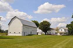 Farmstead on Irvin Shoots Road | |
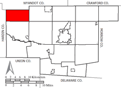 Location of Grand Township in Marion County | |
| Coordinates: 40°39′51″N 83°22′8″W | |
| Country | United States |
| State | Ohio |
| County | Marion |
| Area | |
| • Total | 18.2 sq mi (47.2 km2) |
| • Land | 18.2 sq mi (47.2 km2) |
| • Water | 0.0 sq mi (0.0 km2) |
| Elevation | 889 ft (271 m) |
| Population (2010) | |
| • Total | 391 |
| • Density | 21.5/sq mi (8.3/km2) |
| Time zone | UTC-5 (Eastern (EST)) |
| • Summer (DST) | UTC-4 (EDT) |
| FIPS code | 39-31178[2] |
| GNIS feature ID | 1086577[1] |
Geography
Located in the northwestern corner of the county, it borders the following townships:
- Marseilles Township, Wyandot County - north
- Salt Rock Township - east
- Big Island Township - southeast corner
- Montgomery Township - south
- Dudley Township, Hardin County - southwest corner
- Goshen Township, Hardin County - west
No municipalities are located in Grand Township.
Name and history
It is the only Grand Township statewide.[3]
Government
The township is governed by a three-member board of trustees, who are elected in November of odd-numbered years to a four-year term beginning on the following January 1. Two are elected in the year after the presidential election and one is elected in the year before it. There is also an elected township fiscal officer,[4] who serves a four-year term beginning on April 1 of the year after the election, which is held in November of the year before the presidential election. Vacancies in the fiscal officership or on the board of trustees are filled by the remaining trustees.
References
- "US Board on Geographic Names". United States Geological Survey. 2007-10-25. Retrieved 2008-01-31.
- "U.S. Census website". United States Census Bureau. Retrieved 2008-01-31.
- "Detailed map of Ohio" (PDF). United States Census Bureau. 2000. Retrieved 2007-02-16.
- §503.24, §505.01, and §507.01 of the Ohio Revised Code. Accessed 4/30/2009.
External links
Municipalities and communities of Marion County, Ohio, United States | ||
|---|---|---|
| City |  Map of Ohio highlighting Marion County | |
| Villages | ||
| Townships | ||
| Unincorporated communities | ||
| Ghost town | ||