Gradišče pri Ormožu
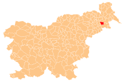
Gradišče pri Ormožu (pronounced [ɡraˈdiːʃtʃɛ pri ˈoːrmɔʒu]) is a small settlement in the Slovene Hills (Slovene: Slovenske gorice) northwest of Ormož in northeastern Slovenia. It belongs to the Municipality of Sveti Tomaž, which became an independent municipality in 2006. The area traditionally belonged to the Styria region and is now included in the Drava Statistical Region.[2]
Gradišče pri Ormožu | |
|---|---|
 Gradišče pri Ormožu Location in Slovenia | |
| Coordinates: 46°28′24.52″N 16°4′37.04″E | |
| Country | |
| Traditional region | Styria |
| Statistical region | Drava |
| Municipality | Sveti Tomaž |
| Area | |
| • Total | 0.2 km2 (0.08 sq mi) |
| Elevation | 283.5 m (930.1 ft) |
| Population (2002) | |
| • Total | 41 |
| [1] | |
Name
The name of the settlement was changed from Gradišče to Gradišče pri Ormožu in 1953.[3]
gollark: Available here with the rest of the licensing documentation: https://pastebin.com/NdUKJ07j
gollark: See? It's clearly missing many of the important features of potatOS. And the privacy policy.
gollark: The original is here (https://pastebin.com/RM13UGFa) line 43.
gollark: Sorry it's gray on white, I'm screenshotting pastebin.
gollark: OpenOS lacks many of potatOS's distinctive features.
References
- Statistical Office of the Republic of Slovenia
- Sveti Tomaž municipal site
- Spremembe naselij 1948–95. 1996. Database. Ljubljana: Geografski inštitut ZRC SAZU, DZS.
This article is issued from Wikipedia. The text is licensed under Creative Commons - Attribution - Sharealike. Additional terms may apply for the media files.
