Grade I and II* listed buildings in the London Borough of Enfield
There are over 9,000 Grade I listed buildings and 20,000 Grade II* listed buildings in England. This page is a list of these buildings in the London Borough of Enfield.
Grade I
| Name | Location | Type | Completed [note 1] | Date designated | Grid ref.[note 2] Geo-coordinates |
Entry number [note 3] | Image |
|---|---|---|---|---|---|---|---|
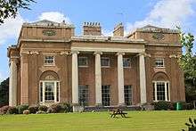
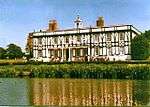
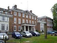
| Forty Hall | Forty Hill, Enfield | House | 1629–1636 | 19 March 1951 | TQ3364098561 51°40′12″N 0°04′08″W |
1294469 | |
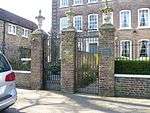
| Screen wall, gateway and north pavilions to west of Forty Hall | Forty Hill, Enfield | Gate | c. 1630 | 19 March 1951 | TQ3366598576 51°40′12″N 0°04′07″W |
1079565 | 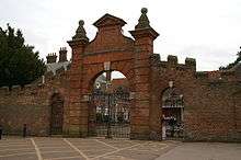 Screen wall, gateway and north pavilions to west of Forty Hall |
| Grovelands Park Hospital (original Block Only) | Enfield | Hospital | 1797 | 31 January 1974 | TQ3038694275 51°37′56″N 0°07′03″W |
1078925 |

Grade II*
| Name | Location | Type | Completed [note 1] | Date designated | Grid ref.[note 2] Geo-coordinates |
Entry number [note 3] | Image |
|---|---|---|---|---|---|---|---|
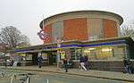
| Arnos Grove Underground station | Enfield | Underground Railway Station | Opened 1932 | 19 February 1971 | TQ2932092482 51°36′59″N 0°08′01″W |
1358981 | |
| Arnoside House and Essex House | Southgate, Enfield | House | Early 18th century | 12 June 1950 | TQ2981993475 51°37′30″N 0°07′34″W |
1358705 | |
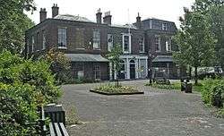
| Broomfield House, Broomfield Park | Enfield | House | Early 18th century | 12 June 1950 | TQ3045292653 51°37′03″N 0°07′02″W |
1078934 | |
| East Wall of Broomfield Park Including Attached Garden House and Stable Block | Enfield | Gate | Mid 16th century | 12 June 1950 | TQ3045492548 51°37′00″N 0°07′02″W |
1188544 |  East Wall of Broomfield Park Including Attached Garden House and Stable Block |
| Capel House | Enfield | House | Mid-late 18th century | 19 March 1951 | TQ3434299687 51°40′48″N 0°03′30″W |
1078898 | |
| Christ Church Southgate | Southgate, Enfield | Parish Church | 1861 | 12 June 1950 | TQ2968393418 51°37′29″N 0°07′41″W |
1294372 |  Christ Church Southgate |
| Church of All Saints Edmonton Parish Church | Edmonton, Enfield | Church | 12th century | 10 April 1954 | TQ3398293660 51°37′33″N 0°03′57″W |
1079548 | |
| Church of St Andrew's Enfield | Enfield | Church | 1800 | 19 March 1951 | TQ3278196656 51°39′11″N 0°04′55″W |
1079549 | |
| Church of St Mary Magdalene | Windmill Hill, Enfield | Church | 1897–1899 | 31 January 1974 | TQ3173196750 51°39′15″N 0°05′50″W |
1294385 | |
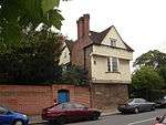
| Clarendon Cottage | Enfield | House | 17th century | 19 March 1951 | TQ3247296791 51°39′16″N 0°05′11″W |
1079527 | 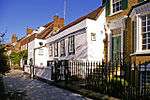 Clarendon Cottage |
| Forecourt Walls, Railings and Gates to Number 4 (Essex House) and Number 5 (Arnoside House) | Southgate, Enfield | Gate | Early 18th century | 31 January 1974 | TQ2982893456 51°37′30″N 0°07′33″W |
1079535 | |
| Formerly Arnos Grove Southgate House (central section) | Enfield | House | 1722 | 12 June 1950 | TQ3001393238 51°37′23″N 0°07′24″W |
1294639 | |
| Lamb's Cottage | Edmonton, Enfield | House | Late 17th century or early 18th century | 14 January 1950 | TQ3419493647 51°37′32″N 0°03′46″W |
1188759 | 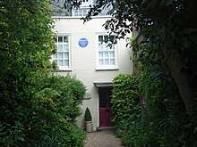 Lamb's Cottage |
| Millfield House | Upper Edmonton, Enfield | Country House | Late 18th century | 31 January 1974 | TQ3301292539 51°36′57″N 0°04′49″W |
1079504 | |
| North East Building of Enfield Grammar School | Enfield | School | Late 16th century | 19 March 1951 | TQ3274596662 51°39′11″N 0°04′57″W |
1079551 |  North East Building of Enfield Grammar School |
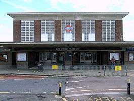
| Oakwood Underground station | Enfield | Booking Office | Built 1933 | 19 February 1971 | TQ2933895972 51°38′52″N 0°07′55″W |
1078930 | |
| St John the Evangelist, Palmers Green, with Parish Room | Palmer's Green, Enfield | Church | 1907–1908 | 31 January 1974 | TQ3129493350 51°37′25″N 0°06′17″W |
1078929 |  St John the Evangelist, Palmers Green, with Parish Room |
| Salisbury House | Enfield | House | Modern | 10 April 1954 | TQ3335094515 51°38′01″N 0°04′29″W |
1188620 | |
| Southgate House | Southgate, Enfield | House | Late 18th century | 12 June 1950 | TQ2974993946 51°37′46″N 0°07′37″W |
1079541 | |
| Southgate Underground station | Southgate, Enfield | Underground station | 1933 | 19 February 1971 | TQ2967194269 51°37′56″N 0°07′40″W |
1188692 | |
| Pylons to north and south of Southgate Underground station | Southgate, Enfield | Lamp post, sign and seat | 1933 | 19 February 1971 | 51°37′57″N 0°07′41″W | 1359011 |  Pylons to north and south of Southgate Underground station |
| Stable Building to the Hermitage | Forty Hill, Enfield | House | Late 17th century or early 18th century | 19 March 1951 | TQ3353098244 51°40′02″N 0°04′14″W |
1189040 | 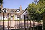 Stable Building to the Hermitage |
| The Paddocks | Crews Hill, Enfield | Farmhouse | Early-Mid 17th century | 9 December 1983 | TL3103600506 51°41′17″N 0°06′21″W |
1100968 |  |


.jpg)

Notes
- The date given is the date used by Historic England as significant for the initial building or that of an important part in the structure's description.
- Sometimes known as OSGB36, the grid reference is based on the British national grid reference system used by the Ordnance Survey.
- The "List Entry Number" is a unique number assigned to each listed building and scheduled monument by Historic England.
External links

This article is issued from Wikipedia. The text is licensed under Creative Commons - Attribution - Sharealike. Additional terms may apply for the media files.