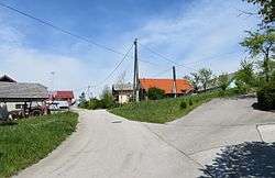
Gorenja Vas pri Čatežu
Gorenja Vas pri Čatežu (pronounced [ɡɔˈɾeːnja ˈʋaːs pɾi ˈtʃaːtɛʒu]; Slovene: Gorenja vas pri Čatežu) is a small settlement to the east of Čatež in the Municipality of Trebnje in eastern Slovenia. Traditionally the area was part Lower Carniola and is now included in the Southeast Slovenia Statistical Region.[2]
Gorenja Vas pri Čatežu | |
|---|---|
 | |
 Gorenja Vas pri Čatežu Location in Slovenia | |
| Coordinates: 45°57′55.92″N 14°58′21.97″E | |
| Country | |
| Traditional region | Lower Carniola |
| Statistical region | Southeast Slovenia |
| Municipality | Trebnje |
| Area | |
| • Total | 0.53 km2 (0.20 sq mi) |
| Elevation | 442.1 m (1,450.5 ft) |
| Population (2002) | |
| • Total | 31 |
| [1] | |
Name
The name of the settlement was changed from Gorenja vas to Gorenja vas pri Čatežu in 1953.[3]
gollark: I can't be bothered to grep through all my ebooks and check, but I think there was also a ram head involved.
gollark: That comes under incomprehensible sorcery.
gollark: That runs on ants and incomprehensible sorcery, but close enough I guess.
gollark: I know you meant thermite, but a termite-based one would also be very funny if you made the case or something out of wood.
gollark: Yes, "server destruction device" does seem very fun, you can imagine all sorts of interesting scenarios.
References
- Statistical Office of the Republic of Slovenia
- Trebnje municipal site
- Spremembe naselij 1948–95. 1996. Database. Ljubljana: Geografski inštitut ZRC SAZU, DZS.
External links
This article is issued from Wikipedia. The text is licensed under Creative Commons - Attribution - Sharealike. Additional terms may apply for the media files.
