Gmina Chodów
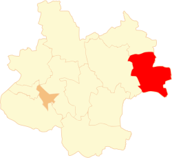
Gmina Chodów is a rural gmina (administrative district) in Koło County, Greater Poland Voivodeship, in west-central Poland. Its seat is the village of Chodów, which lies approximately 27 kilometres (17 mi) east of Koło and 144 km (89 mi) east of the regional capital Poznań.
Gmina Chodów Chodów Commune | |
|---|---|
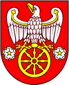
 Flag  Coat of arms | |
 | |
| Coordinates (Chodów): 52°15′N 19°1′E | |
| Country | |
| Voivodeship | Greater Poland |
| County | Koło |
| Seat | Chodów |
| Area | |
| • Total | 77.97 km2 (30.10 sq mi) |
| Population (2006) | |
| • Total | 3,475 |
| • Density | 45/km2 (120/sq mi) |
The gmina covers an area of 77.97 square kilometres (30.1 sq mi), and as of 2006 its total population is 3,475.
Villages
Gmina Chodów contains the villages and settlements of Aleksandrów, Bowyczyny, Budy-Gole, Chodów, Chrzanowo, Czerwonka, Długie, Domaników, Dziegielewo, Dzierzbice, Elizanów, Gąsiory, Ignacewo, Jagiełłów, Kaleń Duża, Kaleń Mała, Kocewia Duża, Koserz, Niwki, Nowe Niwki, Nowy Koserz, Nowy Rdutów, Pniewo, Rdutów, Stanisławów, Studzień, Szołajdy, Turzynów, Wewierz, Wojciechowo and Zieleniec.
Neighbouring gminas
Gmina Chodów is bordered by the gminas of Dąbrowice, Daszyna, Grabów, Kłodawa, Krośniewice and Przedecz.