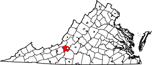
Glenvar, Virginia
Glenvar is a census-designated place (CDP) in western Roanoke County, Virginia, United States. The population as of the 2010 Census was 976.[4] The center of the community lies along US 11/US 460 about one mile west of the Salem city limits.[5] The community is home to Glenvar High School which serves most of the western sections of Roanoke County. As a result, the entire area of Roanoke County which is west of Salem and in the Roanoke Valley between Poor Mountain and Fort Lewis Mountain, including other communities such as Wabun, Fort Lewis, and Dixie Caverns, is often called Glenvar.
Glenvar | |
|---|---|
Census-designated place (CDP) | |
 Location within the Commonwealth of Virginia | |
| Coordinates: 37°16′26″N 080°08′02″W | |
| Country | United States |
| State | Virginia |
| County | Roanoke |
| Elevation | 1,089 ft (332 m) |
| Population (2010)[2] | |
| • Total | 976 |
| Time zone | UTC-5 (Eastern (EST)) |
| • Summer (DST) | UTC-4 (EDT) |
| ZIP code | 24153 |
| Area code | 540 |
| FIPS code[2][3] | 51-31488 |
| GNIS feature ID[1][3] | 1494959 |
References
- "Feature Detail Report: Glenvar". Geographic Names Information System. United States Geological Survey. Retrieved August 6, 2008.
- "Places: Virginia". 2010 Census Gazetteer Files. United States Census Bureau. Archived from the original on June 26, 2014. Retrieved May 9, 2014.
- "FIPS55 Data: Virginia". FIPS55 Data. United States Geological Survey. February 23, 2006. Archived from the original on June 18, 2006.
- "Virginia Trend Report 2: State and Complete Places (Sub-state 2010 Census Data)". Missouri Census Data Center. Archived from the original on July 11, 2012. Retrieved August 6, 2008.
- "Glenvar, VA 24153". Google Maps. Retrieved August 6, 2008.
This article is issued from Wikipedia. The text is licensed under Creative Commons - Attribution - Sharealike. Additional terms may apply for the media files.
