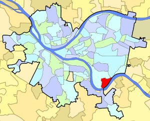
Glen Hazel (Pittsburgh)
Glen Hazel is a neighborhood in Pittsburgh, Pennsylvania's east city area. It has both zip codes of 15207 and 15217, and has representation on Pittsburgh City Council by Corey O'Connor.
Glen Hazel | |
|---|---|
 | |
| Coordinates: 40.406°N 79.929°W | |
| Country | United States |
| State | Pennsylvania |
| County | Allegheny County |
| City | Pittsburgh |
| Area | |
| • Total | 0.456 sq mi (1.18 km2) |
| Population (2010)[1] | |
| • Total | 716 |
| • Density | 1,600/sq mi (610/km2) |
From small well-kept row houses near the river to larger, two-story brick homes on top of the hill, housing in Hazelwood and Glen Hazel are varied and affordable.
The communities of Glen Hazel and Hazelwood, which lie along the Monongahela River, once flourished with an abundance of hazelnut trees. Beautiful places to live in the nineteenth century, they attracted some of Pittsburgh's oldest and wealthiest families, who built magnificent homes there. But the coming of the railroad and industry changed the neighborhoods. The wealthy departed, and the "good life" was redefined, as working-class men and women moved in to tend the furnaces and the coke ovens. Hazelwood and Glen Hazel are two of the city's most ethnically-diverse neighborhoods.
Glen Hazel and Hazelwood are family-oriented neighborhoods, with many of their community activities focusing on youth programs. The neighborhoods are noted for their numerous churches and the active roles they play in building community spirit and pride in their residents.
Surrounding and connecting Pittsburgh neighborhoods
Situated along the Monongahela River, most of Glen Hazel is bordered by Hazelwood and shares a small border with Squirrel Hill South to the northeast. The Glenwood Bridge across the Monongahela connects Glen Hazel to another Pittsburgh neighborhood, Hays, to the south.
References
- "PGHSNAP 2010 Raw Census Data by Neighborhood". PGHSNAP Utility. Pittsburgh Department of City Planning. 2012. Retrieved 24 June 2013.
Further reading
- Toker, Franklin (1994) [1986]. Pittsburgh: An Urban Portrait. Pittsburgh: University of Pittsburgh Press. ISBN 0-8229-5434-6.